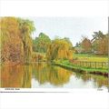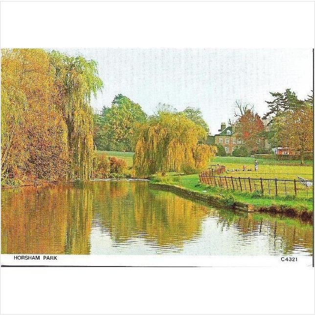

Horsham, W Sussex - Horsham Park - Judges postcard c.1970s
- Condition : Used
- Dispatch : 2 Days
- Brand : None
- ID# : 129854160
- Quantity : 1 item
- Views : 180
- Location : United Kingdom

- Seller : justthebook (+1699)
- Barcode : None
- Start : Thu 03 Jul 2014 18:11:21 (EDT)
- Close : Run Until Sold
- Remain : Run Until Sold
Checks/Cheques
 for 1 item(s) edit
Shipping Calculator
More Listings from This Seller view all


Seller's Description
- Postcard
- Picture / Image: Horsham Park, West Sussex
- Publisher: Judges of Hastings
- Postally used: no
- Stamp: n/a
- Postmark(s): n/a
- Sent to: n/a
- Notes / condition:
Please ask if you need any other information and I will do the best I can to answer.
Image may be low res for illustrative purposes - if you need a higher definition image then please contact me and I may be able to send one. No cards have been trimmed (unless stated).
------------------------------------------------
Postage & Packing:
Postage and packing charge should be showing for your location (contact if not sure).
No additional charges for more than one postcard. You can buy as many postcards from me as you like and you will just pay the fee above once. Please wait for combined invoice. (If buying postcards with other things such as books, please contact or wait for invoice before paying).
Payment Methods:
UK - PayPal, Cheque (from UK bank) or postal order
Outside UK: PayPal ONLY (unless otherwise stated) please. NO non-UK currency checks or money orders (sorry).
NOTE: All postcards are sent in brand new stiffened envelopes which I have bought for the task. These are specially made to protect postcards and you may be able to re-use them. In addition there are other costs to sending so the above charge is not just for the stamp!
I will give a full refund if you are not fully satisfied with the postcard.
----------------------------------------------
Text from the free encyclopedia WIKIPEDIA may appear below to give a little background information (internal links may not work) :
*************
Horsham /'h?r??m/ is a market town with a population of 55,657 (2008)[citation needed] on the upper reaches of the River Arun in the centre of the Weald, West Sussex, in the historic County of Sussex, England. The town is 31 miles (50 km) south south-west of London, 18.5 miles (30 km) north-west of Brighton and 26 miles (42 km) north-east of the county town of Chichester. Nearby towns include Crawley to the north-east and Haywards Heath and Burgess Hill to the south-east. It is the administrative and market centre of Horsham District Council area.
Horsham holds the UK record for the heaviest hailstone ever to fall. On 5 September 1958, a hailstone weighing 140g (4.9 oz) landed in the town. It was similar in size to a tennis ball and impact speeds have been calculated to be 100 m/s (224 mph).[2]
Horsham has an elevation of 50 metres (160 ft) above sea level,[3] it is situated in the centre of the Weald in the Low Weald, at the very western edge of the High Weald, with the Surrey Hills of the North Downs to the north and the Sussex Downs of the South Downs to the south.[4] The River Arun rises from ghylls (streams) in the St Leonard's Forest area, to the east of Horsham, cuts through the south of the town then makes its way through Broadbridge Heath. It is joined by a number of streams flowing down from the northern rising around Rusper.
Horsham has grown up around the Carfax (see landmarks), which is a meeting area place of four roads. To the south of the Carfax is the Causeway. This tranquil street consists of houses erected in the 17th, 18th and early 19th century and is lined with ancient London Plane trees. The Horsham Museum is situated at the northerly end opposite to the recently developed former headquarters of the R.S.P.C.A.. At the south end of the Causeway is the Church of England parish church of St. Mary: Norman in origin, rebuilt in the 13th century and restored in 1864–65 by the Gothic revival architect S.S. Teulon.[5] The area immediately to the south of the parish church is known as Normandy. It was formerly an area of artisans cottages and an ancient well. Moving south for fifty metres and the River Arun is encountered. On the northern bank is Prewett's Mill and on the south side is the town's cricket field. A short walk along the banks of the Arun in a south easterly direction is Chesworth Farm, an area of open public access.
To the north of the Carfax is a large park, known locally as Horsham Park, the remnant of what was formerly the Hurst Park Estate. The park has numerous football pitches, a wildlife pond and tennis courts. Various leisure facilities, including a modern swimming complex and a purpose built gymnastic centre, have been built on land around the park.
To the east along Brighton Road is Iron Bridge named after the railway bridge that carries the railway from London Victoria to Littlehampton. The area consists of mainly Victorian and Edwardian houses to the north of Brighton Road, whilst to the south there are areas of inter- and post-war housing. This area is known as the East Side.
Horsham has developed beyond the original boundaries to incorporate some of the smaller hamlets which now form part of the outer neighbourhoods.
An area of Horsham named after a feeder stream of the River Arun. It consists of residential housing, the majority of which is of late twentieth-century origin. The suburb is substantial enough for two council wards. The hamlet around Old Holbrook House is immediately to the north of the A264 which abuts Holbrook. Holbrook House was previously the home of Sir William Vesey-Fitzgerald, Governor of Bombay and M.P. for Horsham (1852–1875). The Tithe Barn at Fivens Green is the most notable building in the district.
This hamlet dates back to the late 18th Century, when a small number of houses were in existence, with an inn opening in the early part of the 19th Century. A station opened in the area in 1907, originally called Rusper Road Crossing halt, but later renamed Littlehaven.[6]
South-west of the town the Needles estate was laid out from c. 1955, with a mixture of privately owned and council-built houses and bungalows. Land around Hills Farm nearby was sold for development in 1972 and further development took place in the 1980s.[6] The Needles are named after a local farmhouse, called so as it was built using timbers from ships wrecked on The Needles formation.[7]
type=printed postcards
theme=topographical: british
sub-theme=england
county/ country=sussex
number of items=single
period=1945 - present
postage condition=unposted
Listing Information
| Listing Type | Gallery Listing |
| Listing ID# | 129854160 |
| Start Time | Thu 03 Jul 2014 18:11:21 (EDT) |
| Close Time | Run Until Sold |
| Starting Bid | Fixed Price (no bidding) |
| Item Condition | Used |
| Bids | 0 |
| Views | 180 |
| Dispatch Time | 2 Days |
| Quantity | 1 |
| Location | United Kingdom |
| Auto Extend | No |