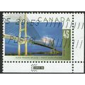
Bournemouth, Dorset - Roysdean, Derby Road - RP postcard 1958 pmk
- Condition : Used
- Dispatch : 2 Days
- Brand : None
- ID# : 182511404
- Quantity : 1 item
- Views : 124
- Location : United Kingdom

- Seller : justthebook (+1704)
- Barcode : None
- Start : Mon 10 Jun 2019 08:56:50 (EDT)
- Close : Run Until Sold
- Remain : Run Until Sold
Checks/Cheques
 for 1 item(s) edit
Shipping Calculator
More Listings from This Seller view all
Seller's Description
- Postcard
- Picture / Image: Roysdean, Derby Road, Bournemouth [with views of the town: East Cliff Beach / Childrens Pool / The Square / Central Gardens
- Publisher: Hannering Foster, Bournemouth [printers]
- Postally used: yes
- Stamp: 2&half d Wilding
- Postmark(s): Bournemouth & Poole 1958 slogan (Territorial Army Golden Jubilee)
- Sent to: Tydeman Street, Swindon, Wilts.
- Notes / condition:
Please ask if you need any other information and I will do the best I can to answer.
Image may be low res for illustrative purposes - if you need a higher definition image then please contact me and I may be able to send one. No cards have been trimmed (unless stated).
------------------------------------------------
Postage & Packing:
Postage and packing charge should be showing for your location (contact if not sure).
No additional charges for more than one postcard. You can buy as many postcards from me as you like and you will just pay the fee above once. Please wait for combined invoice. (If buying postcards with other things such as books, please contact or wait for invoice before paying).
Payment Methods:
UK - PayPal, Cheque (from UK bank) or postal order
Outside UK: PayPal ONLY (unless otherwise stated) please. NO non-UK currency checks or money orders (sorry).
NOTE: All postcards are sent in brand new stiffened envelopes which I have bought for the task. These are specially made to protect postcards and you may be able to re-use them. In addition there are other costs to sending so the above charge is not just for the stamp!
I will give a full refund if you are not fully satisfied with the postcard.
----------------------------------------------
Text from the free encyclopedia WIKIPEDIA may appear below to give a little background information (internal links may not work) :
*************
Bournemouth /ˈbɔːrnməθ/ () is a large coastal resort town on the south coast of England to the east of the Jurassic Coast, a World Heritage Site, 96 miles (155 km) long. According to the 2011 census, the town has a population of 183,491 making it the largest settlement in Dorset. With Poole to the west and Christchurch in the east, Bournemouth forms the South East Dorset conurbation, which has a total population of over 465,000.
Before it was founded in 1810 by Lewis Tregonwell, the area was a deserted heathland occasionally visited by fishermen and smugglers. Initially marketed as a health resort, the town received a boost when it appeared in Augustus Granville's 1841 book, The Spas of England. Bournemouth's growth truly accelerated with the arrival of the railway and it became a recognised town in 1870. Historically part of Hampshire, it joined Dorset with the reorganisation of local government in 1974. Since 1997, the town has been administered by a unitary authority, meaning it is independent of Dorset County Council, although it remains part of that ceremonial county. The local council is Bournemouth Borough Council.
The town centre has notable Victorian architecture and the 202-foot (62 m) spire of St Peter's Church, one of three Grade 1 listed churches in the borough, is a local landmark. Bournemouth's location has made it a popular destination for tourists, attracting over five million visitors annually with its beaches and popular nightlife. The town is also a regional centre of business, home of the Bournemouth International Centre or BIC, and a financial sector that is worth more than £1,000 million in gross value added.
Bournemouth is about 94 miles (151 km) southwest of London.[54] The borough borders the neighbouring boroughs of Poole and Christchurch to the west and east respectively and the East Dorset District to the north. Poole Baylies to the South.[55][56] The River Stour forms a natural boundary to the north and east, terminating at Christchurch Harbour;[56][57] while the River Bourne rises in Poole and flows through the middle of Bournemouth town centre, into the English Channel.[58] The towns of Poole, Bournemouth and Christchurch form the South East Dorset conurbation with a combined population of over 400,000. Bournemouth is both a retail and commercial centre.[59]Areas within Bournemouth include: Boscombe, Kinson, Southbourne, Springbourne, Throop, Westbourne and Winton.[60]
The area's geology has little variety, comprising almost entirely of Eocene clays which, prior to urbanisation, supported a heathland environment.[61][62] Patches of the original heath still remain, notably Turbary Common, a 36-hectare (89-acre) site, much of which is designated a Site of Special Scientific Interest.[63] This heathland habitat is home to all six species of native reptile, the Dartford warbler and some important flora such as sundew and bog asphodel. Small populations of Exmoor pony and Shetland cattle help to maintain the area.[64] Bournemouth is directly north of Old Harry Rocks, the easternmost end of the Jurassic Coast, 96 miles (155 km) of coastline designated a World Heritage Site in 2001.[65] Bournemouth's own coastline stretches from Sandbanks to Christchurch Harbour and comprises mainly sandy beaches backed by gravel and sandy clay cliffs. These cliffs are cut by a number of chines which provide natural access to the shore.[66] At the easternmost point lies Hengistbury Head, a narrow peninsula that forms the southern shore of Christchurch Harbour. It is a local nature reserve and the site of a Bronze Age settlement.[67][68]
Listing Information
| Listing Type | Gallery Listing |
| Listing ID# | 182511404 |
| Start Time | Mon 10 Jun 2019 08:56:50 (EDT) |
| Close Time | Run Until Sold |
| Starting Bid | Fixed Price (no bidding) |
| Item Condition | Used |
| Bids | 0 |
| Views | 124 |
| Dispatch Time | 2 Days |
| Quantity | 1 |
| Location | United Kingdom |
| Auto Extend | No |


![8oz French Lavender Hydrating Body Lotion[ ]](https://pic.ebid.net/upload_small/4/3/0/1746171558-30538-23.jpg)