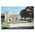
Shoreham-by-Sea, W Sussex - Church (St Mary) - postcard by N&ACB c.1920s
- Condition : Used
- Dispatch : 2 Days
- Brand : None
- ID# : 209311774
- Quantity : 1 item
- Views : 116
- Location : United Kingdom

- Seller : justthebook (+1703)
- Barcode : None
- Start : Mon 04 Jul 2022 17:44:14 (BST)
- Close : Run Until Sold
- Remain : Run Until Sold
 for 1 item(s)
More Listings from This Seller view all


Seller's Description
- Postcard
- Picture / Image: Shoreham [by Sea, West Suusex] - church [St Mary de Haura]
- Publisher: N & ACB
- Postally used: no - has pencilled message
- Stamp: n/a
- Postmark(s): n/a
- Sent to: n/a
- Notes / condition:
Please ask if you need any other information and I will do the best I can to answer.
Image may be low res for illustrative purposes - if you need a higher definition image then please contact me and I may be able to send one. No cards have been trimmed (unless stated).
------------------------------------------------
Postage & Packing:
Postage and packing charge should be showing for your location (contact if not sure).
No additional charges for more than one postcard. You can buy as many postcards from me as you like and you will just pay the fee above once. Please wait for combined invoice. (If buying postcards with other things such as books, please contact or wait for invoice before paying).
Payment Methods:
UK and all other locations - PayPal or other methods listed above.
NOTE: All postcards are sent in brand new stiffened envelopes which I have bought for the task. These are specially made to protect postcards and you may be able to re-use them.
I will give a full refund if you are not fully satisfied with the postcard.
----------------------------------------------
Text from the free encyclopedia WIKIPEDIA may appear below to give a little background information (internal links may not work) :
*************
Shoreham-by-Sea (often shortened to Shoreham) is a coastal town and port in West Sussex, England.
The town is bordered to its north by the South Downs, to its west by the Adur Valley and to its south by the River Adur and Shoreham Beach on the English Channel. The town lies in the middle of the ribbon of urban development along the English south coast, approximately equidistant from the city of Brighton and Hove to the east and the town of Worthing to the west. Shoreham covers an area of 2,430 acres (980 ha) and has a population of 20,547 (2011 census).
Old Shoreham dates back to pre-Roman times.[2] St Nicolas' Church, inland by the River Adur, is partly Anglo-Saxon in its construction.[3] The name of the town has an Old English origin.[4] The town and port of New Shoreham was established by the Norman conquerors towards the end of the 11th century.
St Mary de Haura Church (St Mary of the Haven) was built in the decade following 1103 (the Domesday Book was dated 1086), and around this time the town was laid out on a grid pattern that, in essence, still survives in the town centre. The present church is approximately half the size of the original structure – the former nave was already in ruins by the time of the civil war although sizeable remnants of the original west façade survive in the churchyard to this day.
Muslim scholar Muhammad al-Idrisi, writing c.1153, described Shoreham as "a fine and cultivated city containing buildings and flourishing activity".[5]
The rapid growth of the neighbouring towns of Brighton, Hove and Worthing – and in particular the arrival of the railway in 1840 – prepared the way for Shoreham's rise as a Victorian sea port, with several shipyards and an active coasting trade. Shoreham Harbour remains in commercial operation today. The area became an urban district, with Shoreham Town Hall as its headquarters, in 1910.[6]
Shoreham Beach
Shoreham Beach, to the south of the town, is a shingle spit deposited over millennia by longshore drift. This blocks the southerly flow of the River Adur which turns east at this point to discharge into the English Channel further along the coast at a point that has varied considerably over time. During the 17th and 18th centuries, the mouth of the river shifted eastwards which restricted trade to the port; by 1810 it was almost opposite Aldrington church. In 1816, work had been completed to fix the position of the river in its present position, flowing into the sea between two piers. Once the harbour mouth was stabilised it was defended by Shoreham Fort which was built in 1857.[7]
Converted railway carriages became summer homes around the start of the 20th century, and 'Bungalow Town', as it was then known, became home to the early British film industry. Francis L. Lyndhurst, founded the Sunny South Film Company, which made its first commercial movie on Shoreham Beach in 1912 and built a film studio there.[8][9] Shoreham Beach officially became part of Shoreham-by-Sea in 1910. Much of the housing in the area was cleared for defence reasons during the Second World War and most of what remained after the war is now long gone, having been replaced by modern houses, some of which are extremely expensive, architect designed constructions.[10] The Church of the Good Shepherd, built in 1913, still stands. Along the Adur mud flats adjacent to Shoreham Beach sits (and at high tides floats) a large collection of houseboats made from converted barges, tugs, mine sweepers,[11] Motor Torpedo Boats etc. The seaside shingle bank of Shoreham beach extends further east past the harbour mouth, forming the southern boundary of the commercial harbour in Southwick, Portslade and Hove. The Monarch's Way long-distance footpath, commemorating the flight of Charles II to France after the Battle of Worcester, follows the beach westwards from Hove past Portslade and Southwick, terminating by the harbour mouth's east breakwater.
Landscape and wildlife
With the River Adur, the downs and the sea nearby the area supports a diverse wildlife flora and fauna.[citation needed] The mudflats support wading birds and gulls, including the ringed plover which attempts to breed on the coastal shingle.[citation needed] The pied wagtail is common in the town in the winter months. Insects include dragonflies over the flood plains of the river. The south and west facing downs attract at least 33 species of butterfly including a nationally important population of the chalkhill blue butterfly on Mill Hill.[12] The underlying rock is chalk on the downs, with alluvium in the old river channels. The Adur district has a variety of habitats in a small area, including natural chalk downs and butterfly meadows, freshwater and reed beds, salt marsh and estuary, brackish water lagoons, woodland, shingle seashore, chalk platform undersea and large expanses of sand.
The town is the end-point of the Monarch's Way, a 615-mile (990 km) Long-distance footpath, based on the escape route taken by King Charles II in 1651 after being defeated by Cromwell in the Battle of Worcester.[13]
St Mary de Haura Church is an Anglican church in the ancient "New Shoreham" area of Shoreham-by-Sea in the district of Adur, one of seven local government districts in the English county of West Sussex. It was founded at the end of the 11th century as a large cruciform church which, due to its original scale, has been described as a collegiate church—a reflection of the port of Shoreham's importance at the time. The former east end of that building survives to form the present church, and much 12th-century work remains. It functions as Shoreham-by-Sea's "town church" for major religious and social events, as well as serving as the town-centre parish. English Heritage has listed it at Grade I for its architectural and historical importance.
Old Shoreham was a mostly agricultural village on the east bank of the River Adur.[1] Claims that it was founded near the place (Cymenshore) where Ælle of Sussex—the first King of the South Saxons—came ashore in 477 have been disproved, but it had become a successful village by the time of the Domesday survey in 1086, supporting a population of 76.[1] In the decade after this, William de Braose, 1st Lord of Bramber or his son Philip founded a new settlement to the south, on the estuary where the Adur flowed into the English Channel. This may have been a result of William de Braose's failure to gain control of the harbour upstream at Steyning.[1]
The settlement, named New Shoreham, was planned on a grid pattern of streets based around the High Street.[1][2] Its harbour quickly became prosperous and successful: it overcame the competition from contemporary inland Sussex ports such as Arundel and Steyning, and gained royal patronage when King John's fleet was stationed there in the early 13th century.[2] Its importance was further enhanced by its position as the closest English Channel port to London.[1][3]
William the Conqueror had granted the Rape of Bramber, one of the six Rapes (subdivisions) of Sussex, to the de Braose family in the 11th century. Shortly afterwards, they founded a new church to serve the new settlement.[2] William de Braose died no later than 1096, which has been suggested as the date of founding,[4] but the first documentary evidence was a deed dated 1103, referring to Philip de Braose's return from the First Crusade.[5] At this time, he granted the advowson of the church to an abbey in the French town of Saumur, which held it until about 1250.[4][5] This abbey had an associated priory at Sele (present-day Upper Beeding), further up the river Adur, which became the church's patron in 1250. The patronage later transferred to Magdalen College, Oxford, and in 1948 to the Bishop of Chichester.[4] Locally, the church had originally been administered from St Nicolas' Church in Old Shoreham, but it was given its own parish in the late 12th century. The two churches have been part of a united benefice, served by the same vicar, since 1897, however.[4]
The present building—a large edifice itself, bigger than the small-scale buildings of the town—[6][7] is merely the surviving east section of a much more substantial church, which would have been cruciform when built by the de Braoses.[4][7] Although it was never more than a parish church,[6] it may have been planned as a priory or collegiate church, or would have become one if the Port of Shoreham and the de Braose family had retained the power and influence they had in the 12th and 13th centuries.[4][6][7][8] By 1500, however, no male heirs were left and the de Braoses' estates and holdings were broken up; and erosion and changing tidal activity made the port dangerous to sail into and had washed away parts of the grid-pattern town.[2] New Shoreham was therefore left with a church of a much larger scale than it could support—it was described by Edward Augustus Freeman[6] as "a parish church absolutely without a fellow in England".
As originally built, the church had a tower and a nave, beyond which was a chancel with an apse and east-facing rounded chapels at the east end;[7] the outline of these can still be discerned.[5] Later in the 12th century (probably from the 1170s onwards)[5][9] everything beyond the nave was replaced with a tall, expansive quire with five bays, a quadripartite (four-celled) rib vault, aisles with their own vaulting, a triforium and a clerestory.[4][5][9] This work took several decades and was undertaken for William de Braose, 3rd Lord of Bramber, Philip de Braose's son.[8] Flying buttresses were added to the exterior to support the vaulted aisles soon after they were built—an early usage of this structural technique.[7]
The church had reached its greatest physical extent by about 1225, when this work was completed.[7] Its influence was also at its highest, as it had gained administrative independence from St Nicolas' Church, the de Braoses still wielded considerable power and the Port of Shoreham was thriving:[9] King John stationed ships there and established a prison in 1221. New Shoreham even challenged Chichester's long-established position as the county town.[1] A vicarage was founded in 1261; it was disestablished in 1897 when the vicarages of Old and New Shoreham were combined in a united benefice.[4]
Over the following centuries, Shoreham's influence declined as its old trade routes (especially to France) were lost and the port was affected by erosion.[2][4] Minor structural alterations took place, such as the construction of a porch, a rood screen and an accompanying altar, but the fabric of the church gradually disintegrated.[4] It worsened during the 17th century, and the original (1130s) nave collapsed in storms in about 1700,[4][6][8] reducing the length of the church by about half.[7] The rubble was cleared in the early 18th century,[9] although part of one of the bays survived and has been incorporated into a porch.[10] The quire was altered to form a new nave and chancel.[4][9]
During the 19th century, some work was undertaken in the interior, including Arthur Loader's replacement of some original Perpendicular Gothic-style aisle windows with Norman-style equivalents in 1876.[4][11] The north transept was converted into a memorial for the war dead after the Second World War.[4]
Listing Information
| Listing Type | Gallery Listing |
| Listing ID# | 209311774 |
| Start Time | Mon 04 Jul 2022 17:44:14 (BST) |
| Close Time | Run Until Sold |
| Starting Bid | Fixed Price (no bidding) |
| Item Condition | Used |
| Bids | 0 |
| Views | 116 |
| Dispatch Time | 2 Days |
| Quantity | 1 |
| Location | United Kingdom |
| Auto Extend | No |