Romford, Gtr London / Essex - North Street - repro postcard
- Condition : Used
- Dispatch : 2 Days
- Brand : None
- ID# : 102928885
- Quantity : 1 item
- Views : 1036
- Location : United Kingdom

- Seller : justthebook (+1703)
- Barcode : None
- Start : Sat 20 Apr 2013 18:32:42 (BST)
- Close : Run Until Sold
- Remain : Run Until Sold
 for 1 item(s)
More Listings from This Seller view all


Seller's Description
- Postcard
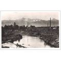
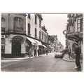
- Picture / Image: North Street, Old Romford, Essex (now Greater London)
- Publisher: RRC / printed by FN Johnson & Co, Ongar, Essex c.1980s
- Postally used: no
- Stamp: n/a
- Postmark(s): n/a
- Sent to: n/a
- Notes / condition:
Please ask if you need any other information and I will do the best I can to answer.
------------------------------------------------
Postage & Packing:
UK (incl. IOM, CI & BFPO): 99p
Europe: £1.60
Rest of world (inc. USA etc): £2.75
No additional charges for more than one postcard. You can buy as many postcards from me as you like and you will just pay the fee above once. (If buying postcards with other things such as books, please contact or wait for invoice before paying).
Payment Methods:
UK - PayPal, Cheque (from UK bank) or postal order
Outside UK: PayPal ONLY (unless otherwise stated) please. NO non-UK currency checks or money orders (sorry).
NOTE: All postcards are sent in brand new stiffened envelopes which I have bought for the task. These are specially made to protect postcards and you may be able to re-use them. In addition there are other costs to sending so the above charge is not just for the stamp!
I will give a full refund if you are not fully satisfied with the postcard.
----------------------------------------------
Text from the free encyclopedia WIKIPEDIA may appear below to give a little background information (internal links may not work) :
*************
Romford is a large suburban town in northeast London,[2] United Kingdom and the administrative headquarters of the London Borough of Havering. It is located 14.1 miles (22.7 km) northeast of Charing Cross and is one of the major metropolitan centres identified in the London Plan.[3] It was historically a market town in the county of Essex[4] and formed the administrative centre of the liberty of Havering, until it was dissolved in 1892.[5] Good road links and the opening of the railway station in 1839 were key to the development of the town[4] and the economic history of Romford is underpinned by a shift from agriculture to light industry and more recently to retail and commerce.[4] As part of the suburban growth of London in the 20th century, Romford significantly expanded and increased in population,[6] becoming a municipal borough in 1937[7] and has formed part of Greater London since 1965.[8] It now forms one of the largest commercial, retail, entertainment and leisure districts outside central London[1] and has a developed night time economy.
Romford is first recorded in 1177 as Romfort, which is formed from Old English 'rum' and 'ford' and means ""the wide or spacious ford"".[11] The naming of the River Rom is a local 'back-formation' from the name of the town; and the river is elsewhere known as the Beam. The ford most likely existed on the main London to Colchester road where it crossed that river.[11]
The town developed in the Middle Ages on the main road to London and the regionally significant Romford Market was established in 1247.[4] The early history of Romford and the immediate area is agricultural and it is recorded as being the location of a number of mills used to grind corn.[4] The area was a focus of the leather industry from the 15th to the early 19th centuries and there is record of a wide range of industries such as cloth making, weaving, charcoal burning, metal working and brewing.[4] Communications played an important part in its development; the main road to London was maintained by the Middlesex and Essex Turnpike Trust from 1721 and Romford became a coaching town in the 18th century.[12] Several failed attempts were made in the early 19th century to connect the town to the Thames via a Romford Canal. Initially intended to transport agricultural products to London and later intended to serve growing industrial sites in Romford, only two miles of canal were constructed and the canal company were unable to reach the town.[13]
The development of the town was accelerated by the opening of the railway station in 1839 which stimulated the local economy and was key to the development of the Star Brewery. Initially Eastern Counties Railway services operated between Mile End and Romford, with extensions to Brentwood and to Shoreditch in 1840. A second station was opened on South Street in 1892 by the London, Tilbury and Southend Railway on the line to Upminster and Grays, giving Romford a rail connection to Tilbury Docks. The two stations were combined into one in 1934.[12] Light industry slowly developed, reaching a peak in the 1970s with a number of factories on the edge of town, such as the Roneo Vickers office machinery company, Colvern manufacturers of wireless components, May's Sheet Metal Works and brush manufacturers Betterware.[4] Suburban expansion increased the population and reinforced Romford's position as a significant regional town centre. The Liberty Shopping Centre was constructed in the 1960s and has been recently modernised and supplemented with further shopping centres throughout the town, including The Mall, opened in 2006; and The Brewery, opened in 2000 on the site of the old Star Brewery.[14]
type=printed postcards
theme=topographical: british
sub-theme=england
county/ country=essex
number of items=single
period=1945 - present
postage condition=unposted
Listing Information
| Listing Type | Gallery Listing |
| Listing ID# | 102928885 |
| Start Time | Sat 20 Apr 2013 18:32:42 (BST) |
| Close Time | Run Until Sold |
| Starting Bid | Fixed Price (no bidding) |
| Item Condition | Used |
| Bids | 0 |
| Views | 1036 |
| Dispatch Time | 2 Days |
| Quantity | 1 |
| Location | United Kingdom |
| Auto Extend | No |