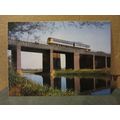
Port Talbot, Neath Port Talbot - beach - Plastichrome postcard c.1960s
- Condition : Used
- Dispatch : 2 Days
- Brand : None
- ID# : 212064840
- Quantity : 1 item
- Views : 111
- Location : United Kingdom

- Seller : justthebook (+1703)
- Barcode : None
- Start : Tue 08 Nov 2022 15:42:28 (BST)
- Close : Run Until Sold
- Remain : Run Until Sold
 for 1 item(s)
More Listings from This Seller view all


Seller's Description
- Postcard
- Picture / Image: Beach looking West, Port Talbot
- Publisher: Baxter & Crabtree / Plastchrome
- Postally used: yes
- Stamp: 3d purple Wilding
- Postmark(s): Port Talbot 1967
- Sent to: Woodward Road, Kidderminster
- Notes / condition:
Please ask if you need any other information and I will do the best I can to answer.
Image may be low res for illustrative purposes - if you need a higher definition image then please contact me and I may be able to send one. No cards have been trimmed (unless stated).
------------------------------------------------
Postage & Packing:
Postage and packing charge should be showing for your location (contact if not sure).
No additional charges for more than one postcard. You can buy as many postcards from me as you like and you will just pay the fee above once. Please wait for combined invoice. (If buying postcards with other things such as books, please contact or wait for invoice before paying).
Payment Methods:
UK - PayPal, Cheque (from UK bank) or postal order
Outside UK: PayPal ONLY (unless otherwise stated) please. NO non-UK currency checks or money orders (sorry).
NOTE: All postcards are sent in brand new stiffened envelopes which I have bought for the task. These are specially made to protect postcards and you may be able to re-use them. In addition there are other costs to sending so the above charge is not just for the stamp!
I will give a full refund if you are not fully satisfied with the postcard.
----------------------------------------------
Text from the free encyclopedia WIKIPEDIA may appear below to give a little background information (internal links may not work) :
*************
Port Talbot (/ˌpɔːrt
Modern Port Talbot is a town formed from the merging of multiple villages, including Baglan, Margam, and Aberafan. The name 'Port Talbot' first appears in 1837 as the name of the new docks built on the south east side of the river Afan by the Talbot family. Over time it came to be applied to the whole of the emerging conurbation.[4][5]
The earliest evidence of humans in the Port Talbot area has been found on the side of Mynydd Margam where Bronze Age farming ditches can be found from 4,000 BC. There were Iron Age hill forts on Mynydd Dinas, Mynydd Margam, Mynydd Emroch and other nearby hills. Mynydd Hawdef contains remains of an ancient Iron Age village. The Margam deer herd was first introduced by the Romans.[6][7]
Ffynnon Pedr is a sacred spring or well which flows from the hillside through a stone culvert 0.4m square in Margam. It is possibly the water supply for Margam Abbey 0.75 km to the East.[8]
The Cross of Brancuf an early Christian Sculptured Stone which stands in the church of St Catharine at Baglan. It is an intricately sculptured cross-slab with a Latin cross and an inscription recalling Brancuf. Originally it stood in the old St Baglan's church but that fell into ruin in the late 19th century and the slab was removed to St Catharine's. St Baglan (Bagelan), son of King Ithael Hoel of Brittany, was a 6th-century hermit and follower of St Illytud. He founded the first church at the town that now takes his name. In the vestry of St Catharine's church a cross-slab dating from the 8th-10th century CE. It is intricately decorated with a Celtic-style cross formed out of knotwork (cord-plait knotwork) and interlacing; the ends of each arm are probably of a Latin design. Also there is a Latin inscription: FECIT BRANCUF or perhaps BRANCU which when translated reads 'was made by Brancuf'. However, the person known as Brancuf is unknown.[9]
The English antiquarian John Leland made an extensive journey through Wales c.1536-39 of which he recorded an itinerary. He passed through Aberafan, which he describes as a "poor village" surrounded by barren ground, though he also describes the area as heavily wooded, not much of which remains today. He mentions the use of the river mouth as a port. His portrayal of Aberafan as a small, struggling village suggests that the port was not in great use, especially as traffic to and from Margam Abbey would have ceased following its dissolution in 1536.[10]
Listing Information
| Listing Type | Gallery Listing |
| Listing ID# | 212064840 |
| Start Time | Tue 08 Nov 2022 15:42:28 (BST) |
| Close Time | Run Until Sold |
| Starting Bid | Fixed Price (no bidding) |
| Item Condition | Used |
| Bids | 0 |
| Views | 111 |
| Dispatch Time | 2 Days |
| Quantity | 1 |
| Location | United Kingdom |
| Auto Extend | No |