Meon Valley, Hampshire - Curbridge Botley Titchfield Swanwick Station - postcard
- Condition : Used
- Dispatch : 2 Days
- Brand : None
- ID# : 140990302
- Quantity : 1 item
- Views : 421
- Location : United Kingdom

- Seller : justthebook (+1695)
- Barcode : None
- Start : Mon 20 Jul 2015 17:17:33 (BST)
- Close : Run Until Sold
- Remain : Run Until Sold
 for 1 item(s)
More Listings from This Seller view all


Seller's Description
- Postcard
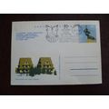
- Picture / Image: Meon Valley Postcard Club multiview postcard: The Horse and Jockey Pub, Curbridge c.1900s / Swanwick Railway Station 1989 / Botley High Street, 1989 / Titchfield Waterworks, c.1900
- Publisher: Meon Valley Postcard Club, c.1989
- Postally used: no
- Stamp: n/a
- Postmark(s): n/a
- Sent to: n/a
- Notes / condition: bumped corner
Please ask if you need any other information and I will do the best I can to answer.
Image may be low res for illustrative purposes - if you need a higher definition image then please contact me and I may be able to send one. No cards have been trimmed (unless stated).
------------------------------------------------
Postage & Packing:
Postage and packing charge should be showing for your location (contact if not sure).
No additional charges for more than one postcard. You can buy as many postcards from me as you like and you will just pay the fee above once. Please wait for combined invoice. (If buying postcards with other things such as books, please contact or wait for invoice before paying).
Payment Methods:
UK - PayPal, Cheque (from UK bank) or postal order
Outside UK: PayPal ONLY (unless otherwise stated) please. NO non-UK currency checks or money orders (sorry).
NOTE: All postcards are sent in brand new stiffened envelopes which I have bought for the task. These are specially made to protect postcards and you may be able to re-use them. In addition there are other costs to sending so the above charge is not just for the stamp!
I will give a full refund if you are not fully satisfied with the postcard.
----------------------------------------------
Text from the free encyclopedia WIKIPEDIA may appear below to give a little background information (internal links may not work) :
*************
The River Meon is a river that flows through an area of Hampshire in southern England known as the Meon Valley, it flows generally southwards from the South Downs to the Solent. For most of its route it is a chalk stream, with a length of 21 miles (34 km).[2]
The River Meon rises approximately one mile (1.6 km) south of the village of East Meon. It first flows due north to that village, then northwest to West Meon, and southwest to Warnford before adopting its principal southwards flow. From Warnford the river flows through the villages of Exton, Corhampton and Meonstoke, Droxford, Wickham, and Titchfield. From Titchfield the river flows some 2 miles (3.2 km) through the marshes of the Titchfield Haven National Nature Reserve before entering the Solent through the small harbour at Hill Head.[3]
Until late in the 17th century, the River Meon was navigable as far as Titchfield, which at that time was a significant port. However silting started to restrict the passage of ships, and in order to maintain Titchfield's status as a port, the Earl of Southampton proposed that a canal should be constructed (Titchfield Canal). This canal opened in 1611 and was only the second canal existing in Britain at the time.[citation needed] The canal also suffered from silting, so the sea trade moved to nearby Southampton and Portsmouth. As part of the construction of the canal, the outfall of the River Meon to the sea was dammed, creating the wetlands that now form the Titchfield Haven National Nature Reserve.[2]
Swanwick is a village in Hampshire, England, east of the River Hamble and north of the M27 motorway. The village is located within the borough of Fareham and is the site of the London Area Control Centre (LACC) and the London Terminal Control Centre (LTCC) part of National Air Traffic Services Air Traffic Control Centre and also the last remaining example of a Victorian steam-powered brickworks, located at Bursledon Brickworks[1].
Swanwick has no real village centre and the only commercial premises of note is the Elm Tree Public House. Since the 1980s, the gradual spread of housing developments has meant that Swanwick has partly merged with the new development of Whiteley although there is no direct vehicular access except for a bus only route.
Swanwick railway station on the West Coastway Line is approximately one mile south of the village and is nearer Park Gate than Swanwick.
The village's ""twin"" Lower Swanwick is situated two miles west of the village on the edge of the River Hamble.
Botley is a historic village in Hampshire, England that obtained a charter for a market from Henry III in 1267. The area has been settled since at least the 10th century.
Between 1806 and 1820 it was the home of the famous journalist and radical politician William Cobbett,[1] who described the village as the most delightful in the world. There is a memorial stone to William Cobbett in the village square.
Flour mills have existed in Botley for over 1,000 years; the old Botley Mill is at the end of High Street.
The fine Market Hall, built in 1848, and old coaching inns can be found in the High Street together with many interesting houses.
The village itself grew around a ford over the River Hamble (which powered the mill) where an Inn was built for travellers to stay in overnight on occasions when the tide was in. At high tide small boats such as canoes can still navigate up the River Hamble, which runs through the village.
Nowadays, the village can be easily accessed from Eastleigh and Fareham by train. Previously, a rail service operated to Bishops Waltham along the Bishops Waltham Branch Line.[2] Botley railway station is just outside the modern boundary of Botley, within Curdridge.
In nearby Curbridge is Fairthorne Manor, a day camps centre run by the YMCA, which includes a golf course, the Fairthorne Manor Golf Course, and farm
Titchfield is a village in southern Hampshire, by the River Meon. The village has a history stretching back to the 6th century. During the medieval period, the village operated a small port and market. Near to the village are the ruins of Titchfield Abbey, a place with strong associations with Shakespeare, through his patron, the Earl of Southampton.
To the east of Titchfield lies the town of Fareham, to the south are Stubbington, Hill Head and the Solent, to the west is Locks Heath, Warsash, the River Hamble and Southampton and to the north is Whiteley, Park Gate and Swanwick . Titchfield forms part of the Borough of Fareham, having been added to the Fareham urban district in 1932.[1]
Several miles to the south of the village, at the mouth of the River Meon and on the shores of the Solent, is Titchfield Haven National Nature Reserve, where there is a small harbour that dries out at low tide. Inland is a Nature Reserve which is an important breeding and visiting ground for many species of birds and wildfowl (and is open to visitors at certain periods).[2]
Near to the village and the haven lies the Titchfield Canal, earlier known as the New River. It has been suggested that this is the second oldest canal in England, completed in 1611[citation needed] (Exeter was the first).[1] However, as late as 1676 two tenants, John Cooper and John Landy, complained in the Manorial Court that the Lord of the Manor ""by Cutting ye new River hath taken away and doth detain"" parts of their copyholds, implying that in 1676 the construction was recent. It lies close to Titchfield Haven, concealed by a bridge with the remains of a sea-lock at the south end. A footpath follows the canal to Titchfield village. It was certainly used for flooding the water meadows, traces of which can still be clearly seen. Whether it was ever used as a navigation channel is still debated. The Earl of Southampton ordered the river to be sealed off from the sea by a wall which was an unpopular move with the villagers as it ultimately ended Titchfield's role as a port.[1]
type=printed
city/ region=meon valley
period=post-war (1945 - present)
postage condition=unposted
number of items=single
size=continental/ modern (150x100mm)
Listing Information
| Listing Type | Gallery Listing |
| Listing ID# | 140990302 |
| Start Time | Mon 20 Jul 2015 17:17:33 (BST) |
| Close Time | Run Until Sold |
| Starting Bid | Fixed Price (no bidding) |
| Item Condition | Used |
| Bids | 0 |
| Views | 421 |
| Dispatch Time | 2 Days |
| Quantity | 1 |
| Location | United Kingdom |
| Auto Extend | No |