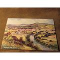
Fort William, Highland - Photochrom multiview postcard 1957
- Condition : Used
- Dispatch : 2 Days
- Brand : None
- ID# : 125000806
- Quantity : 1 item
- Views : 237
- Location : United Kingdom

- Seller : justthebook (+1704)
- Barcode : None
- Start : Fri 28 Feb 2014 10:23:16 (BST)
- Close : Run Until Sold
- Remain : Run Until Sold
 for 1 item(s)
More Listings from This Seller view all


Seller's Description
- Postcard
- Picture / Image: Fort William, Highland - multiview: Sgurr a'Mhaim & Stob Ban from Glen Nevis / Loch Linnhe & Ben Nevis / SS Loch Fyne passing Ben Kiel / Fort William and Loch Linnhe from Cow Hill / Highland Cattle in centre
- Publisher: Photochrom
- Postally used: yes
- Stamp: 2d. brown Wilding defin.
- Postmark(s): illeg. cds but date is 1957
- Sent to: Bolney Avenue, Peacehaven, Sussex
- Notes / condition:
Please ask if you need any other information and I will do the best I can to answer.
Image may be low res for illustrative purposes - if you need a higher definition image then please contact me and I may be able to send one.
------------------------------------------------
Postage & Packing:
UK (incl. IOM, CI & BFPO): 99p
Europe: £1.60
Rest of world (inc. USA etc): £2.75
No additional charges for more than one postcard. You can buy as many postcards from me as you like and you will just pay the fee above once. (If buying postcards with other things such as books, please contact or wait for invoice before paying).
Payment Methods:
UK - PayPal, Cheque (from UK bank) or postal order
Outside UK: PayPal ONLY (unless otherwise stated) please. NO non-UK currency checks or money orders (sorry).
NOTE: All postcards are sent in brand new stiffened envelopes which I have bought for the task. These are specially made to protect postcards and you may be able to re-use them. In addition there are other costs to sending so the above charge is not just for the stamp!
I will give a full refund if you are not fully satisfied with the postcard.
----------------------------------------------
Text from the free encyclopedia WIKIPEDIA may appear below to give a little background information (internal links may not work) :
*************
Fort William (Scottish Gaelic: An Gearasdan (?n 'k??r?s?t??n), ""The Garrison"") is the second largest settlement in the highlands of Scotland and the largest town: only the city of Inverness is larger.
Fort William is a major tourist centre with Glen Coe just to the south, Aonach Mòr to the north and Glenfinnan to the west, on the Road to the Isles. It is a centre for hillwalking and climbing due to its proximity to Ben Nevis and many other Munro mountains. It is also known for its nearby downhill mountain bike track. It is the start/end of both the West Highland Way (Milngavie/Fort William) and the Great Glen Way; a walk/cycle way (Fort William/Inverness).
Around 726 people (7.33% of the population) can speak Gaelic.[1]
Historically, this area of Lochaber was strongly Clan Cameron country, and there were a number of mainly Cameron settlements in the area (such as Blarmacfoldach). The nearby settlement of Inverlochy was the main settlement in the area before the building of the fort, and was also site of the Battle of Inverlochy.
The town grew up as a settlement next to a fort constructed to control the population after Oliver Cromwell's invasion during the English Civil War, and then to suppress the Jacobite uprisings of the 18th century. The fort was named ""Fort William""' after William of Orange, and the settlement that grew around it was called ""Maryburgh"", after his wife. This settlement was later renamed ""Gordonsburgh"", and then ""Duncansburgh""[2] before being renamed ""Fort William"", this time after Prince William, Duke of Cumberland; known to some Scots as ""Butcher Cumberland"". Given these origins, there have been various suggestions over the years to rename the town (for example, to ""Invernevis""). These proposals have led to nothing yet.
In the Jacobite rising known as the Forty-Five, Fort William was besieged for two weeks by the Jacobites, from 20 March to 3 April 1746. However, although the Jacobites had captured both of the other forts in the chain of three Great Glen fortifications (Fort Augustus and the original Fort George) they failed to take Fort William.
During the Second World War, Fort William was the home of HMS St Christopher which was a training base for Royal Navy Coastal Forces.
More on the history of the town and the region can be found in the West Highland Museum on the High Street.
Fort William is the northern end of the West Highland Way, a long distance route which runs 95 miles through the Scottish Highlands to Milngavie, on the outskirts of Glasgow, and the start/end point of the Great Glen Way, which runs between Fort William and Inverness.
On 2 June 2006, a fire destroyed McTavish's Restaurant in Fort William High Street along with the two shops which were part of the building. The restaurant had been open since the 1970s and prior to that the building had been Fraser's Cafe since the 1920s. Development work began in 2012 on new hotel accommodation and street-level shops. It is unclear when this project will be completed.
type=printed postcards
theme=topographical: british
sub-theme=scotland
county/ country=inverness-shire
number of items=single
period=1945 - present
postage condition=posted
Listing Information
| Listing Type | Gallery Listing |
| Listing ID# | 125000806 |
| Start Time | Fri 28 Feb 2014 10:23:16 (BST) |
| Close Time | Run Until Sold |
| Starting Bid | Fixed Price (no bidding) |
| Item Condition | Used |
| Bids | 0 |
| Views | 237 |
| Dispatch Time | 2 Days |
| Quantity | 1 |
| Location | United Kingdom |
| Auto Extend | No |