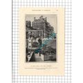
Folkestone, Kent - Harbour, fishing boats - Paragon RP postcard c.1950s
- Condition : Used
- Dispatch : 2 Days
- Brand : None
- ID# : 110261326
- Quantity : 1 item
- Views : 1104
- Location : United Kingdom

- Seller : justthebook (+1704)
- Barcode : None
- Start : Fri 21 Jun 2013 00:22:49 (BST)
- Close : Run Until Sold
- Remain : Run Until Sold
 for 1 item(s)
More Listings from This Seller view all


Seller's Description
- Postcard
- Picture / Image: The Harbour, Folkestone, Kent - real photo
- Publisher: A. H. & S. 'Paragon Series', Margate
- Postally used: no
- Stamp: n/a
- Postmark(s): n/a
- Sent to: n/a
- Notes / condition:
Please ask if you need any other information and I will do the best I can to answer.
------------------------------------------------
Postage & Packing:
UK (incl. IOM, CI & BFPO): 99p
Europe: £1.60
Rest of world (inc. USA etc): £2.75
No additional charges for more than one postcard. You can buy as many postcards from me as you like and you will just pay the fee above once. (If buying postcards with other things such as books, please contact or wait for invoice before paying).
Payment Methods:
UK - PayPal, Cheque (from UK bank) or postal order
Outside UK: PayPal ONLY (unless otherwise stated) please. NO non-UK currency checks or money orders (sorry).
NOTE: All postcards are sent in brand new stiffened envelopes which I have bought for the task. These are specially made to protect postcards and you may be able to re-use them. In addition there are other costs to sending so the above charge is not just for the stamp!
I will give a full refund if you are not fully satisfied with the postcard.
----------------------------------------------
Text from the free encyclopedia WIKIPEDIA may appear below to give a little background information (internal links may not work) :
*************
Folkestone (pron.: /'fo?kst?n/) (population 45,273) is the principal town in the Shepway District of Kent, England. Its original site was in a valley in the sea cliffs and it developed through fishing and its closeness to the Continent as a landing place and trading port. The coming of the railways, the building of a ferry port, and its growing importance as a seaside resort all contributed to its growth. Folkestone has the only sandy beach and coastal park within an hour of north London by High Speed Train.
The area of Folkestone has been occupied since at least the Neolithic, being the shortest crossing point from France. The East Cliff area has recently been excavated and produced finds from the Paleolithic period through to the Roman Era, when settlement moved to the Bayle area of the town. On the East Cliff there was an extensive Iron Age settlement and harbour which, amongst other industry, produced thousands of quernstones over at least 200 years and traded with the near continent for many commodities including pottery, wine and quernstones. A Roman style villa was constructed in approximately AD100 followed by a more extensive one in about AD200, which was subsequently abandoned in c.AD350.
A Norman knight held a Barony of Folkestone, by which time the settlement had become a fishing village[citation needed]. That led to its entry as a part of the Cinque Ports in the thirteenth century and with that the privilege of being a wealthy trading port. At the start of the Tudor period it had become a town in its own right. Wars with France meant that defences had to be built here and soon plans for a Folkestone Harbour began. Folkestone, like most settlements on the south coast, became involved in smuggling during the eighteenth century[citation needed]. At the beginning of the 1800s a harbour was developed, but it was the coming of the railways in 1843 that would have the bigger impact. With it came the tourist trade, and the two industries contributed to its prosperity until changes in tourist opportunities in the mid twentieth century hollowed out its economy[citation needed].
Until the 19th century Folkestone remained a small fishing community with a seafront that was continually battered by storms and encroaching shingle that made it hard to land boats. In 1807 an Act of Parliament was passed to build a pier and harbour which was built by Thomas Telford in 1809.[2] By 1820 a harbour area of 14 acres (5.7 hectares) had been enclosed. Folkestone's trade and population grew slightly but development was still hampered by sand and silt from the Pent Stream. The Folkestone Harbour Company invested heavily in removing the silt but with little success. In 1842 the company became bankrupt and the Government put the derelict harbour up for sale. It was bought by the South Eastern Railway Company (SER), which was then building the London to Dover railway line. George Turnbull was responsible in 1844 for building the Horn pier.[3][4] Dredging the harbour, and the construction of a rail route down to it, began almost immediately, and the town soon became the SER’s principal packet station for the Continental traffic to Boulogne.
Folkestone Harbour Company commissioned Foster Associates to produce a masterplan for Folkestone which was published in April 2006. The plans describe the rebuilding of the harbour as a marina, a ""Green Wave"" along the sea front linking countryside west and east of the town, new housing, shops, a performance area and small university campus. The plans take in the land that was previously the Rotunda Amusement Park. Progress in developing the area has been inhibited by the recession and by new guidelines governing flood protection. A new approach to the seafront is being developed by Terry Farrell and Partners, and the former fairground site is being considered for temporary recreational use whilst planning takes place.[5]
However, there is an alternative plan being developed by the Remembrance Line Association[6] which is based on retaining the harbour railway and its station as a major heritage/tourist operation and 'Leaving for War' museum given the significance of the Folkestone Harbour Branch in both World Wars which is important to the Allied and Commonwealth nations. The harbour railway station, now unused, is gradually succumbing to nature.
Although Kent was the first part of the British mainland to be conquered and settled by the invading Angles, Saxons and Jutes from the middle of the 5th century AD onwards, after the departure of the Romans, it was not until the late 7th century that the spelling Folcanstan appears. One suggestion is that this refers to Folca's stone;[7] another suggestion is that it came from an Old English personal name, with the addition of stone, possibly meaning, in this context, ""meeting place"". It was not until the mid 19th century that the spelling of ""Folkestone"" was fixed as such, with the Earl of Radnor requesting that the town's name be standardised (although this tendency towards standardisation in the 19th century is true of English place names generally). Folkestone is often misspelt, variants including Folkston, Folkstone & Folkeston.
The governance of Folkestone lies in both national and local government. Insofar as national government is concerned, Folkestone is part of the constituency of Folkestone and Hythe, which is currently (2010) represented by Damian Collins (Conservative). In the European Parliament, Folkestone is part of the South East England constituency, with ten MEPs.
Local government consists of three tiers. In the first tier, Kent County Council, Folkestone is divided into three Divisions each returning one County Councillor. Folkestone North East comprises Park, Foord and East wards and is represented by Cllr Richard Pascoe (Conservative). Folkestone South comprises Harvey West, Harvey Central and Harbour wards and is represented by Cllr Roland Tolputt (Conservative). Folkestone West comprises Cheriton and Morehall wards and neighbouring Sandgate Parish Council. It is represented by Cllr Tim Prater (Liberal Democrat).[8] The next elections are scheduled for June 2013.
The second tier of local government is the non-metropolitan district. Folkestone forms a part of Shepway District, which was established by the Local Government Act 1972. Folkestone elects 18 of Shepway District Council's 46 Councillors, who currently sit as 16 Conservatives and two People First.[9] The next election is due to be held in May 2015.
The third and lowest tier was established as the civil parish: in Folkestone’s case, because it held a Town Charter, and when the then Folkestone Borough Council was abolished, Councillors elected to represent Folkestone's wards were designated as the Town's Charter Trustees, responsible for electing a Town Mayor. This role has since passed to Folkestone Town Council.
Folkestone Town Council was established in 2004,[10] comprising the area of the former Borough of Folkestone less Folkestone Sandgate ward, which was separately parished. Folkestone Town Council comprises eight wards: Cheriton, Kent; Morehall; Park; Harvey West; Harvey Central; Harbour; East; and Foord. Each ward returns two or three members, for a total of 18 Councillors elected to four year terms.[11][12] The next elections are due to be held in May 2015.
Each year, Folkestone Town Councillors attend the Annual General Meeting and Mayor-making ceremony to appoint both a Town Mayor and a Deputy Mayor from their number for the coming year. For the Civic Year 2010/2011, the posts are held: as The Worshipful Town Mayor of Folkestone, Councillor Tom McNeice (Morehall ward); and as Deputy Town Mayor, Cllr Susan Wallace (Harbour ward). The Town Council has three committees: Finance and General Purposes; Planning; and Community Services as well as a Personnel Sub-Committee, a Grievance Panel and numerous Working Groups. The current composition of Folkestone Town Council is 15 Conservatives, two People First and one Liberal Democrats.
Apart from the main town area, Sandgate attained civil parish status in its own right in 2004.
type=real photographic (rp)
theme=topographical: british
sub-theme=england
county/ country=kent
number of items=single
period=post war (1945 - present)
postage condition=unposted
Listing Information
| Listing Type | Gallery Listing |
| Listing ID# | 110261326 |
| Start Time | Fri 21 Jun 2013 00:22:49 (BST) |
| Close Time | Run Until Sold |
| Starting Bid | Fixed Price (no bidding) |
| Item Condition | Used |
| Bids | 0 |
| Views | 1104 |
| Dispatch Time | 2 Days |
| Quantity | 1 |
| Location | United Kingdom |
| Auto Extend | No |