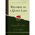
Caton, Lancashire - Crook o'Lune - River with bridge - postcard c.1910
- Condition : Used
- Dispatch : 2 Days
- Brand : None
- ID# : 128323343
- Quantity : 1 item
- Views : 285
- Location : United Kingdom

- Seller : justthebook (+1703)
- Barcode : None
- Start : Mon 19 May 2014 20:16:44 (BST)
- Close : Run Until Sold
- Remain : Run Until Sold
 for 1 item(s)
More Listings from This Seller view all


Seller's Description
- Postcard
- Picture / Image: Caton, Lancashire - 'Crook o'Lune' - shows the River Lune and bridge
- Publisher: A. E. Shaw, Blackburn 'West End' series
- Postally used: no
- Stamp: n/a
- Postmark(s): n/a
- Sent to: n/a
- Notes / condition:
Please ask if you need any other information and I will do the best I can to answer.
Image may be low res for illustrative purposes - if you need a higher definition image then please contact me and I may be able to send one.
------------------------------------------------
Postage & Packing:
UK (incl. IOM, CI & BFPO): 99p
Europe: £1.60
Rest of world (inc. USA etc): £2.75
No additional charges for more than one postcard. You can buy as many postcards from me as you like and you will just pay the fee above once. (If buying postcards with other things such as books, please contact or wait for invoice before paying).
Payment Methods:
UK - PayPal, Cheque (from UK bank) or postal order
Outside UK: PayPal ONLY (unless otherwise stated) please. NO non-UK currency checks or money orders (sorry).
NOTE: All postcards are sent in brand new stiffened envelopes which I have bought for the task. These are specially made to protect postcards and you may be able to re-use them. In addition there are other costs to sending so the above charge is not just for the stamp!
I will give a full refund if you are not fully satisfied with the postcard.
----------------------------------------------
Text from the free encyclopedia WIKIPEDIA may appear below to give a little background information (internal links may not work) :
*************
The civil parish of Caton with Littledale is situated in Lancashire, England near the River Lune. The parish lies within the Forest of Bowland Area of Outstanding Natural Beauty and contains the villages of Caton, Brookhouse, Caton Green, Littledale and Townend.[1]
The original settlement of Caton was renamed Brookhouse after Brookhouse Hall and is separated from modern Caton, originally Town End, by Artle Beck.[2]
Evidence of the Roman occupation in the area is from a mill stone, eight feet long found in Artle Beck in 1803, bearing the name of the Emperor Hadrian; and further engraved stone found some time later.[3]
Archaeological, place name and other evidence attests that Irish-Norse invaders settled in the area in the tenth century (Wainwright 1975). Caton is supposedly named from the Norse personal name Kati (Ekwall 1960), meaning 'cheerful' and ton. Geoffrey Hodgson (2008) argues that the Viking invasion of the area accounts for the relatively high frequency of the Hodgson surname in Caton and elsewhere in Lonsdale.
In late 18th century five mills were built in Town End. Low Mill cotton mill was built for cotton weaving in 1783 on the site of a 13th-century corn mill. it was built by Thomas Hodgson(1738–1817), a slave-trader and son of a Liverpool merchant.(Hodgson 2008) It was powered by a millrace from the Artle Beck at Gresgarth. Water power was replaced by steam in 1819. In the mid 19th century there were two silk mills, two cotton mills, and a flax mill.[3] In 1846 Ball Lane Mill was burnt down. Rumble Row Mill and Forge Mill operated until the 1930s and Willow Mill and Low Mill closed in the 1970s.[4] In 1826 coal and slate were worked in Littledale and bobbins for the mills were made.[5]
Caton was a chapelry composed of four districts; Brookhouse, Caton Green, Littledale, and Town-End, and a township in the ecclesiastical parish of Lancaster in the Lonsdale hundred in Lancashire.[3]
Caton is 5 miles north-east of Lancaster on the road to Hornby in the valley of the River Lune. It covers over 8,000 acres of which 4,000 were moorland where stone was quarried.[3] The township is hilly, Caton Moor in the east rises to over 1,000 feet above sea level and to the south rises to Clougha Pike at 1,355 feet and Ward's Stone at 1,841 feet. The Artle Beck flows in a northerly direction towards the wider flatter valley of the River Lune.[5]
A turnpike road from Lancaster to Hornby and Kirkby Lonsdale, the A683, was constructed in 1812, bypassing the old route through Brookhouse and Caton Green.[4] This road connects Caton to the M6 motorway to the west.
Caton railway station was opened in 1850 on the ""Little"" North Western Railway between Wennington and Lancaster and closed in 1966. The section between Caton and Lancaster is a cycleway.
type=printed postcards
theme=topographical: british
sub-theme=england
county/ country=lancashire
number of items=single
period=pre - 1914
postage condition=unposted
Listing Information
| Listing Type | Gallery Listing |
| Listing ID# | 128323343 |
| Start Time | Mon 19 May 2014 20:16:44 (BST) |
| Close Time | Run Until Sold |
| Starting Bid | Fixed Price (no bidding) |
| Item Condition | Used |
| Bids | 0 |
| Views | 285 |
| Dispatch Time | 2 Days |
| Quantity | 1 |
| Location | United Kingdom |
| Auto Extend | No |