Free Shipping

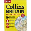
Collins Britain Road Atlas 2016
- Condition : Used
- Dispatch : Next Day
- Brand : Collins
- ID# : 228413699
- Quantity : 1 item
- Views : 87
- Location : United Kingdom

- Seller : Mike91welling11 (+2)
- Barcode : 9780007947737
- Start : Sat 12 Apr 2025 04:54:23 (BST)
- Close : Run Until Sold
- Remain : Run Until Sold
 for 1 item(s)


Seller's Description
Don't just go where the sat nav sends you, plan your own journey with Collins 2016 Britain Essential Road Atlas. With a large scale mapping at 3.2 miles to 1 inch, this road atlas includes: ? Clear and detailed road maps ? 64 town and city maps ? Popular places of interest ? High risk road maps ? Full postcodes for top attractions ? Urban area approach maps to 26 of the busiest areas ? Safety cameras with speed limits Explore the UK by car through accurate and up-to-date mapping with this ultimate travel accessory. This hardback book has 320 pages and measures: 30.5 x 22 x 2cm.
Listing Information
| Listing Type | Platinum Listing |
| Listing ID# | 228413699 |
| Start Time | Sat 12 Apr 2025 04:54:23 (BST) |
| Close Time | Run Until Sold |
| Starting Bid | Fixed Price (no bidding) |
| Item Condition | Used |
| Bids | 0 |
| Views | 87 |
| Dispatch Time | Next Day |
| Quantity | 1 |
| Location | United Kingdom |
| Auto Extend | No |