
Belgium Old 1960s Map Atlas Globe French School Chart Postcard
- Zustand : Siehe Beschr.
- Versand : Am selben Tag
- Marke : Keine
- ID# : 230328605
- Menge : 1 Artikel
- Besucherzahl : 35
- Ort : Großbritannien

- Verkäufer : crowncollectables (+1511)
- Barcode : Keine
- Beginn : Sa 31 Mai 2025 00:00:28 (CEST)
- Ende : Läuft-bis-verkauft
- Verbleibend : Läuft-bis-verkauft
Auslandsversand nach Österreich  von 1 Artikel(n) ändern
von 1 Artikel(n) ändern
Royal Mail International Standard = £4.95 (5,72€)
Versandkostenrechner
Weiteres von diesem Verkäufer Alle anzeigen


Beschreibung (Anbieter)
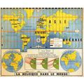
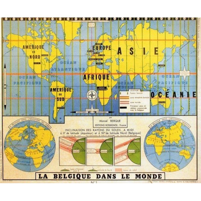
ed3 An incredible and most specialist collectors postcard published circa ten years ago being part of a series of educational wall charts used in schools in France in the 1960s this showing a map of France being the exact educational chart used throughout schools and universities in the mid twentieth century some 60 years ago making this a truly unique opportunity unused and mint
Ausschreibungsinformation
| Ausschreibungsart | Galerie-Ausschreibung |
| Ausschreibung Nr. | 230328605 |
| Startzeit | Sa 31 Mai 2025 00:00:28 (CEST) |
| Endzeit | Läuft-bis-verkauft |
| Startgebot | Festpreis (Bieten nicht möglich) |
| Artikelzustand | Siehe Beschr. |
| Gebote | 0 |
| Besucherzahl | 35 |
| Versandzeit | Am selben Tag |
| Menge | 1 |
| Ort | Großbritannien |
| Automatisch verlängern | Nein |
Neueste Verkäuferbewertungen
Rückgabebestimmungen
Rücksendung akzeptiert