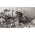
Wastwater, Cumbria RP 1940s postcard
- Condition : Used
- Dispatch : 2 Days
- Brand : None
- ID# : 33029152
- Quantity : 1 item
- Views : 289
- Location : United Kingdom

- Seller : justthebook (+1703)
- Barcode : None
- Start : Mon 25 Oct 2010 09:32:22 (EDT)
- Close : Run Until Sold
- Remain : Run Until Sold
Checks/Cheques
 for 1 item(s) edit
Shipping Calculator
More Listings from This Seller view all


Seller's Description
- Postcard
- Picture / Image: Lovely real photo type card of Wastwater or Wast Water, Cumbria
- Publisher: Northern Photographic Co., Glossop
- Postally used: no
- Stamp: n/a
- Postmark(s): n/a
- Sent to: n/a
- Notes & Key words:
------------------------------------------------
Postage & Packing:
UK (incl. IOM, CI & BFPO): 99p
Europe: £1.60
Rest of world (inc. USA etc): £2.75
No additional charges for more than one postcard. You can buy as many postcards from me as you like and you will just pay the fee above once. (If buying postcards with other things such as books, please contact or wait for invoice before paying).
Payment Methods:
UK - PayPal, Cheque (from UK bank) or postal order
Outside UK: PayPal or Google Checkout ONLY please. NO non-UK currency checks or money orders (sorry).
NOTE: All postcards are sent in brand new stiffened envelopes which I have bought for the task. These are specially made to protect postcards and you may be able to re-use them. In addition there are other costs to sending so the above charge is not just for the stamp!
----------------------------------------------
Text from the free encyclopedia WIKIPEDIA may appear below to give a little background information:
*************
Wast Water or Wastwater is a lake in the Lake District National Park, England. The lake is approximately 4.6 kilometres (almost 3 miles) long and 600 metres (more than a third of a mile) wide, and is located in the Wasdale Valley. It is the deepest lake in England[1] at 79 metres (258 feet), and is owned by the National Trust.
It is one of the finest examples of a glacially 'over-deepened' valley. The surface of the lake is about 200 feet above sea level, while its bottom is over 50 feet below sea level.
The name of the lake and its valley is pronounced as in was, not with a hard a. The lake is named "Wast Water" on Ordnance Survey maps, but the spelling "Wastwater" is used with roughly equal frequency, including by its owner, the National Trust, along with the Cumbria Tourist Board, and the Lake District National Park Authority.
The steep slopes on the south eastern side of the lake, leading up to the summits of Whin Rigg and Illgill Head, are known as the "Wastwater Screes" or on some maps as "The Screes". These screes formed as a result of ice and weathering erosion on the rocks of the Borrowdale Volcanic Group, that form the fells to the east of the lake, towards Eskdale. They are approximately 2,000 feet, from top to base, the base being about 200 feet below the surface of the lake.
The head of the Wasdale Valley is surrounded by some of the highest mountains in England, including Scafell Pike, Great Gable and Lingmell.
Wast Water is the source of the River Irt which flows into the Irish Sea near Ravenglass.
A popular path runs the length of the lake, through the boulders and scree fall at the base of this craggy fell-side. On the north western side are the cliffs of Buckbarrow (a part of Seatallan) and the upturned-boat shape of Yewbarrow.
Listing Information
| Listing Type | Gallery Listing |
| Listing ID# | 33029152 |
| Start Time | Mon 25 Oct 2010 09:32:22 (EDT) |
| Close Time | Run Until Sold |
| Starting Bid | Fixed Price (no bidding) |
| Item Condition | Used |
| Bids | 0 |
| Views | 289 |
| Dispatch Time | 2 Days |
| Quantity | 1 |
| Location | United Kingdom |
| Auto Extend | No |