Sulby Glen & Snaefell, Isle of Man - Carbon Gloss series postcard c.1920s
- Condition : Used
- Dispatch : 2 Days
- Brand : None
- ID# : 106620840
- Quantity : 1 item
- Views : 532
- Location : United Kingdom

- Seller : justthebook (+1703)
- Barcode : None
- Start : Wed 22 May 2013 18:14:04 (EDT)
- Close : Run Until Sold
- Remain : Run Until Sold
Checks/Cheques
 for 1 item(s) edit
Shipping Calculator
More Listings from This Seller view all


Seller's Description
- Postcard
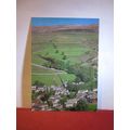
- Picture / Image: Sulby Glen and Snaefell, Isle of Man
- Publisher: 'Carbon Gloss' series
- Postally used: no
- Stamp: n/a
- Postmark(s): n/a
- Sent to: n/a
- Notes / condition:
Please ask if you need any other information and I will do the best I can to answer.
------------------------------------------------
Postage & Packing:
UK (incl. IOM, CI & BFPO): 99p
Europe: £1.60
Rest of world (inc. USA etc): £2.75
No additional charges for more than one postcard. You can buy as many postcards from me as you like and you will just pay the fee above once. (If buying postcards with other things such as books, please contact or wait for invoice before paying).
Payment Methods:
UK - PayPal, Cheque (from UK bank) or postal order
Outside UK: PayPal ONLY (unless otherwise stated) please. NO non-UK currency checks or money orders (sorry).
NOTE: All postcards are sent in brand new stiffened envelopes which I have bought for the task. These are specially made to protect postcards and you may be able to re-use them. In addition there are other costs to sending so the above charge is not just for the stamp!
I will give a full refund if you are not fully satisfied with the postcard.
----------------------------------------------
Text from the free encyclopedia WIKIPEDIA may appear below to give a little background information (internal links may not work) :
*************
Sulby is a parish ofon the primary A2 road which connects Castletown and Ramsey in the Isle of Man. The name of the village of Sulby or Sõlabyr ('Soli's estate')[1] or Sulaby (cleft farm) reflects the Scandinavian influence in Isle of Man place-names.
The old part of Sulby village (grid reference SC382940) is situated on the junction of the primary A14 Tholt-y-Will Road and the secondary B9 Claddagh Road. This part of Old Sulby Village has a Mill and village green. The main part of the village is situated on the primary A2 Road between Close-e-Volley and Ginger Hall. The village is dominated by the Sulby River, the Ballamanaugh farm estate, common land of the Claddagh and Cronk Summark which includes the remains of an iron-age fort.
Snaefell (Manx: Sniaull) is the highest mountain and the only summit higher than 2,000 feet (610 m) on the Isle of Man, at 620 metres (2,034 ft) above sea level. The summit is crowned by a train station, cafe, and several communications masts.
It is a well-known saying in the Isle of Man that on a clear day six kingdoms can be seen from the top: the Isle of Man, England, Ireland, Scotland, Wales and Heaven.[1] Some versions add a seventh kingdom, that of Manannán, (or the Sea).[2]
The plaque at the summit indicates the directions of five points from Snaefell as well as their distances:
- 31 miles (50 km) to the Mull of Galloway (Scotland)
- 51 miles (82 km) to Scafell (England)
- 66 miles (106 km) to the Mountains of Mourne (Northern Ireland)
- 85 miles (137 km) to Liverpool (England)
- 97 miles (156 km) to Dublin (Ireland)
The Snaefell Mountain Railway has a seasonal electric tram service, typically from April to October, which climbs the 4 miles (6.4 km) from Laxey to the summit.
The A18 Snaefell Mountain Road passes over the slopes of Snaefell, and is the highest section of the Snaefell Mountain Course over which the Isle of Man TT Races are held. Walkers often use the car park on this road near the Bungalow railway station (last railway stop before the summit) from which there is a rough path to the peak. The trail has sections of gravel, slate stones, grass, and rock. While the angle of ascent steepens significantly closer to the summit, special climbing equipment is not required. However, caution is required in steep areas as the grass, earth, and rocks are often slippery. Average climb time on foot on a dry footpath is about 45 minutes.
A geodetic marker embedded in the small, concrete obelisk indicates the true mountain summit. The rock cairn standing nearby has an information plaque on top.
type=printed postcards
theme=topographical: british
sub-theme=isle of man
number of items=single
period=inter-war (1918 - 1939)
postage condition=unposted
Listing Information
| Listing Type | Gallery Listing |
| Listing ID# | 106620840 |
| Start Time | Wed 22 May 2013 18:14:04 (EDT) |
| Close Time | Run Until Sold |
| Starting Bid | Fixed Price (no bidding) |
| Item Condition | Used |
| Bids | 0 |
| Views | 532 |
| Dispatch Time | 2 Days |
| Quantity | 1 |
| Location | United Kingdom |
| Auto Extend | No |