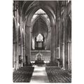
St. Helier, Jersey - Royal Square - 'GF' postcard c.1905
- Condition : Used
- Dispatch : 2 Days
- Brand : None
- ID# : 138006791
- Quantity : 1 item
- Views : 288
- Location : United Kingdom

- Seller : justthebook (+1703)
- Barcode : None
- Start : Sun 29 Mar 2015 19:46:04 (EDT)
- Close : Run Until Sold
- Remain : Run Until Sold
Checks/Cheques
 for 1 item(s) edit
Shipping Calculator
More Listings from This Seller view all


Seller's Description
- Postcard
- Picture / Image: Jersey - Saint-Helier (St. Helier) - Royal Square
- Publisher: 'G. F.'
- Postally used: no
- Stamp: n/a
- Postmark(s): n/a
- Sent to: n/a
- Notes / condition:
Please ask if you need any other information and I will do the best I can to answer.
Image may be low res for illustrative purposes - if you need a higher definition image then please contact me and I may be able to send one. No cards have been trimmed (unless stated).
------------------------------------------------
Postage & Packing:
Postage and packing charge should be showing for your location (contact if not sure).
No additional charges for more than one postcard. You can buy as many postcards from me as you like and you will just pay the fee above once. Please wait for combined invoice. (If buying postcards with other things such as books, please contact or wait for invoice before paying).
Payment Methods:
UK - PayPal, Cheque (from UK bank) or postal order
Outside UK: PayPal ONLY (unless otherwise stated) please. NO non-UK currency checks or money orders (sorry).
NOTE: All postcards are sent in brand new stiffened envelopes which I have bought for the task. These are specially made to protect postcards and you may be able to re-use them. In addition there are other costs to sending so the above charge is not just for the stamp!
I will give a full refund if you are not fully satisfied with the postcard.
----------------------------------------------
Text from the free encyclopedia WIKIPEDIA may appear below to give a little background information (internal links may not work) :
*************
Saint Helier (/s?nt 'h?li?r/; French language: Saint-Hélier [s?~t?elje], Jèrriais: Saint Hélyi) is one of the twelve parishes of Jersey, the largest of the Channel Islands in the English Channel. St. Helier has a population of about 33,500, roughly 34.2% of the total population of Jersey, and is the capital of the Island (although Government House is situated in St. Saviour). The urban area of the parish of St. Helier makes up most of the largest town in Jersey, although some of the town area is situated in adjacent St. Saviour, with suburbs sprawling into St. Lawrence and St. Clement. The greater part of St. Helier is predominantly rural.
The parish covers a surface area of 4.1 square miles (10.6 km2), being 9% of the total land area of the Island (this includes reclaimed land area of 494 acres (2.00 km2) or 200 ha).
The parish crest is two crossed gold axes on a blue background, the blue symbolising the sea, and the axes symbolising the martyrdom of Helier at the hands of Saxon pirates in 555 A.D.
It is thought that the site of St. Helier was settled at the time of the Roman control of Gaul.
The medieval hagiographies of Helier, the patron saint martyred in Jersey and after whom the parish and town are named, suggest a picture of a small fishing village on the dunes between the marshy land behind and the high-water mark.
Although the Parish Church of St Helier is now some considerable distance from the sea, at the time of its original construction it was on the edge of the dunes at the closest practical point to the offshore islet called the Hermitage (site of Helier's witness and martyrdom). Before land reclamation and port construction started, boats could be tied up to the churchyard wall on the seaward side.
An Abbey of St. Helier was founded in 1155 on L'Islet, a tidal island adjacent to the Hermitage. Closed at the Reformation, the site of the abbey was fortified to create the castle that replaced Mont Orgueil as the Island's major fortress. The new Elizabeth Castle was named after the Queen by the Governor of Jersey 1600-1603, Sir Walter Raleigh.
Until the end of the 18th century, the town consisted chiefly of a string of houses, shops and warehouses stretching along the coastal dunes either side of the Church of St. Helier and the adjacent marketplace (since 1751, Royal Square). La Cohue (a Norman word for courthouse) stood on one side of the square, now rebuilt as the Royal Court and States Chamber (called collectively the States Building). The market cross in the centre of the square was pulled down at the Reformation, and the iron cage for holding prisoners was replaced by a prison gatehouse at the western edge of town.
George II gave £200 towards the construction of a new harbour - previously boats would be beached on a falling tide and unloaded by cart across the sands. A statue of the king by John Cheere was erected in the square in 1751 in gratitude, and the market place was renamed Royal Square, although the name has remained Lé Vièr Marchi (the old market) to this day in Jèrriais. Many of St. Helier's road names and street names are bilingual English/French or English/Jèrriais, but some have only one name. The names in the various languages are not usually translations: distinct naming traditions survive alongside each other.
The Royal Square was also the scene of the Battle of Jersey on 6 January 1781, the last attempt by French forces to seize Jersey. John Singleton Copley's epic painting The Death of Major Pierson captures an imaginative version of the scene.
As harbour construction moved development seaward, a growth in population meant that marshland and pasture north of the ribbon of urban activity was built on speculatively. Settlement by English immigrants added quarters of colonial-style town houses to the traditional building stock.
Continuing military threats from France spurred the construction of a citadel fortress, Fort Regent, on the Mont de la Ville, the crag dominating the shallow basin of St. Helier.
Military roads linking coastal defences around the island with St. Helier harbour allowed farmers to exploit Jersey's temperate micro-climate and use new fast sailing ships and then steamships to get their produce to the markets of London and Paris before the competition. This was the start of Jersey's agricultural prosperity in the 19th century.
From the 1820s, peace with France and better communications by steamships and railways to coastal ports encouraged an influx of English-speaking residents. Speculative development covered the marshy basin north of the central coastal strip as far as the hills within a period of about 40 years, providing the town with terraces of elegant town houses.
In the second half of the 19th century, hundreds of trucks laden with potatoes and other export produce needed access to the harbour. This prompted a programme of road-widening which swept away many of the ancient buildings of the town centre. Pressure for redevelopment has meant that very few buildings remain in urban St. Helier which date to before the 19th century, giving the town primarily a Regency or Victorian character.
Pierre Le Sueur, reforming Constable of St. Helier, was responsible for installing sewerage and provision of clean water in St. Helier following outbreaks of cholera in the 1830s. An obelisk with fountain in the town centre was raised to his memory following his premature death in office from overwork.
In the 1970s, a programme of pedestrianisation of the central streets was undertaken.
In 1995, to celebrate the 50th anniversary of Jersey's liberation from Nazi occupation, and thus 50 years of peace, a sculpture was erected in what is now called ""Liberation Square"", in front of the Pomme d'Or Hotel, the focal point for the celebrations when the island was liberated.
The sculpture was originally to depict islanders releasing doves of peace, but this came under fierce criticism, with some islanders remarking that had any doves been on the island during the occupation, they would have been eaten by starving German soldiers. Therefore the sculpture was revised to show islanders raising the British flag, as they had done on the day of liberation 50 years previous.
Liberation Square is now a focal point in the town - the former terminus of the Jersey Railway housed the Jersey Tourism office until 2007.
In 2006, it was reported[2] that the Connétable, with the backing of the Chief Minister of Jersey, was to seek city status for St. Helier.
type=printed
period=pre-1914
postage condition=unposted
number of items=single
size=standard (140x89 mm)
Listing Information
| Listing Type | Gallery Listing |
| Listing ID# | 138006791 |
| Start Time | Sun 29 Mar 2015 19:46:04 (EDT) |
| Close Time | Run Until Sold |
| Starting Bid | Fixed Price (no bidding) |
| Item Condition | Used |
| Bids | 0 |
| Views | 288 |
| Dispatch Time | 2 Days |
| Quantity | 1 |
| Location | United Kingdom |
| Auto Extend | No |