St. Columba's Bay, Iona - postcard 1976, Iona pmk
- Condition : Used
- Dispatch : 2 Days
- Brand : None
- ID# : 180477111
- Quantity : 1 item
- Views : 172
- Location : United Kingdom

- Seller : justthebook (+1703)
- Barcode : None
- Start : Sat 04 May 2019 10:21:31 (EDT)
- Close : Run Until Sold
- Remain : Run Until Sold
Checks/Cheques
 for 1 item(s) edit
Shipping Calculator
More Listings from This Seller view all


Seller's Description
- Postcard
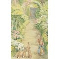
- Picture / Image: St. Columbia's Bay, Iona - Port na Churaich (Port of the Coracle)
- Publisher: The Iona Community
- Postally used: yes
- Stamp: 6&half p turquoise Machin
- Postmark(s): Isle of Iona 27 Aug 1976 cds
- Sent to: Boston, Lincs., England
- Notes / condition:
Please ask if you need any other information and I will do the best I can to answer.
Image may be low res for illustrative purposes - if you need a higher definition image then please contact me and I may be able to send one. No cards have been trimmed (unless stated).
------------------------------------------------
Postage & Packing:
Postage and packing charge should be showing for your location (contact if not sure).
No additional charges for more than one postcard. You can buy as many postcards from me as you like and you will just pay the fee above once. Please wait for combined invoice. (If buying postcards with other things such as books, please contact or wait for invoice before paying).
Payment Methods:
UK - PayPal, Cheque (from UK bank) or postal order
Outside UK: PayPal ONLY (unless otherwise stated) please. NO non-UK currency checks or money orders (sorry).
NOTE: All postcards are sent in brand new stiffened envelopes which I have bought for the task. These are specially made to protect postcards and you may be able to re-use them. In addition there are other costs to sending so the above charge is not just for the stamp!
I will give a full refund if you are not fully satisfied with the postcard.
----------------------------------------------
Text from the free encyclopedia WIKIPEDIA may appear below to give a little background information (internal links may not work) :
*************
Iona (Scottish Gaelic: Ì Chaluim Chille) is a small island in the Inner Hebrides off the Ross of Mull on the western coast of Scotland. It was a centre of Gaelic monasticism for four centuries and is today renowned for its tranquility and natural beauty. It is a popular tourist destination and a place for retreats. Its modern Gaelic name means "Iona of (Saint) Columba" (formerly anglicised "Icolmkill").
The Hebrides have been occupied by the speakers of several languages since the Iron Age, and as a result many of the names of these islands have more than one possible meaning.[6]Nonetheless few, if any, can have accumulated so many different names over the centuries as the island now known in English as "Iona".
The earliest forms of the name enabled place-name scholar William J. Watson to show that the name originally meant something like "yew-place".[7] The element Ivo-, denoting "yew", occurs in Ogham inscriptions (Iva-cattos [genitive], Iva-geni [genitive]) and in Gaulish names (Ivo-rix, Ivo-magus) and may form the basis of early Gaelic names like Eogan (ogham: Ivo-genos).[8][fn 1] It is possible that the name is related to the mythological figure, Fer hÍ mac Eogabail, foster-son of Manannan, the forename meaning "man of the yew".[9]
Mac an Tàilleir (2003) lists the more recent Gaelic names of Ì,[fn 2] Ì Chaluim Chille and Eilean Idhe noting that the first named is "generally lengthened to avoid confusion" to the second, which means "Calum's (i.e. in latinised form "Columba's") Iona" or "island of Calum's monastery".[10][11] The possible confusion results from "ì", despite its original etymology, becoming a Gaelic noun (now obsolete) meaning simply "island".[12] Eilean Idhe means "the isle of Iona", also known as Ì nam ban bòidheach ("the isle of beautiful women"). The modern English name comes of yet another variant, Ioua,[10][11] which was either just Adomnán's attempt to make the Gaelic name fit Latin grammar or else a genuine derivative from Ivova ("yew place").[13] Ioua's change to Iona, attested from c.1274,[14] results from a transcription mistake resulting from the similarity of "n" and "u" in Insular Minuscule.[15][fn 3]
Despite the continuity of forms in Gaelic between the pre-Norse and post-Norse eras, Haswell-Smith (2004) speculates that the name may have a Norse connection, Hiōe meaning "island of the den of the brown bear",[11] "island of the den of the fox", or just "island of the cave".;[16] Nynorsk Hy (from Old Norse Hý) means "sparse grass", or otherwise something furry or shaggy.[17] The medieval English language version was "Icolmkill" (and variants thereof).[11]
Iona lies about 2 kilometres (1 mi) from the coast of Mull. It is about 2 kilometres (1 mi) wide and 6 kilometres (4 mi) long with a resident population of 125.[21] The geology of the island consists mainly of Precambrian Lewisian gneiss with Torridonian sedimentary rocks on the eastern side[22] and small outcrops of pink granite on the eastern beaches. Like other places swept by ocean breezes, there are few trees; most of them are near the parish church.
Iona's highest point is Dùn Ì, 101 metres (331 ft), an Iron Age hill fort dating from 100 BC – AD 200. Iona's geographical features include the Bay at the Back of the Ocean and Càrn Cùl ri Éirinn (the Hill/Cairn of [turning the] Back to Ireland), said to be adjacent to the beach where St. Columba first landed.
The main settlement, located at St. Ronan's Bay on the eastern side of the island, is called Baile Mòr and is also known locally as "The Village". The primary school, post office, the island's two hotels, the Bishop's House and the ruins of the Nunnery are here. The Abbey and MacLeod Centre are a short walk to the north.[4][23] Port Bàn (white port) beach on the west side of the island is home to the Iona Beach Party.[24]
There are numerous offshore islets and skerries: Eilean Annraidh (island of storm) and Eilean Chalbha (calf island) to the north, Rèidh Eilean and Stac MhicMhurchaidh to the west and Eilean Mùsimul (mouse holm island) and Soa Island to the south are amongst the largest.[4] The steamer Cathcart Park carrying a cargo of salt from Runcorn to Wick ran aground on Soa on 15 April 1912, the crew of 11 escaping in two boats.[25][fn 4]
Listing Information
| Listing Type | Gallery Listing |
| Listing ID# | 180477111 |
| Start Time | Sat 04 May 2019 10:21:31 (EDT) |
| Close Time | Run Until Sold |
| Starting Bid | Fixed Price (no bidding) |
| Item Condition | Used |
| Bids | 0 |
| Views | 172 |
| Dispatch Time | 2 Days |
| Quantity | 1 |
| Location | United Kingdom |
| Auto Extend | No |