River, Kent nr Dover - St Peter & St Paul Church - postcard c.1980s
- Condition : Used
- Dispatch : 2 Days
- Brand : None
- ID# : 128323550
- Quantity : 1 item
- Views : 1335
- Location : United Kingdom

- Seller : justthebook (+1703)
- Barcode : None
- Start : Mon 19 May 2014 15:20:12 (EDT)
- Close : Run Until Sold
- Remain : Run Until Sold
Checks/Cheques
 for 1 item(s) edit
Shipping Calculator
More Listings from This Seller view all


Seller's Description
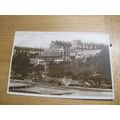
- Postcard
- Picture / Image: St. Peter and St. Paul, River, 1806
- Publisher: Noel Tatt Ltd., Lyminge, Folkestone (Limited Edition postcard)
- Postally used: no but has message
- Stamp: no
- Postmark(s): n/a
- Sent to: n/a
- Notes / condition:
Please ask if you need any other information and I will do the best I can to answer.
Image may be low res for illustrative purposes - if you need a higher definition image then please contact me and I may be able to send one.
------------------------------------------------
Postage & Packing:
UK (incl. IOM, CI & BFPO): 99p
Europe: £1.60
Rest of world (inc. USA etc): £2.75
No additional charges for more than one postcard. You can buy as many postcards from me as you like and you will just pay the fee above once. (If buying postcards with other things such as books, please contact or wait for invoice before paying).
Payment Methods:
UK - PayPal, Cheque (from UK bank) or postal order
Outside UK: PayPal ONLY (unless otherwise stated) please. NO non-UK currency checks or money orders (sorry).
NOTE: All postcards are sent in brand new stiffened envelopes which I have bought for the task. These are specially made to protect postcards and you may be able to re-use them. In addition there are other costs to sending so the above charge is not just for the stamp!
I will give a full refund if you are not fully satisfied with the postcard.
----------------------------------------------
Text from the free encyclopedia WIKIPEDIA may appear below to give a little background information (internal links may not work) :
*************
River is a village and civil parish[1] in Kent, England, United Kingdom, situated between the historic town of Dover and the neighbouring village of Temple Ewell. ""Village"" is a somewhat loose term for River; it is a community of several thousand and is probably more usefully regarded as a suburb of Dover. After a period of rapid housing development in the 1960s and 1970s, the size and population of River has largely stabilised in recent decades, and little new development is now seen. This is partly because River lies in a steep chalk valley which affords little scope for further expansion. However, it is also true that the Dover area is historically not in the vanguard of high economic growth, being tied almost exclusively to the cross-channel port and various support industries, which have witnessed a gradual decline since the opening of the Channel Tunnel. In transport terms River is well connected, being close to the A2 and A20 trunk routes, having a railway station at Kearsney with direct services to London, and of course being only 3 miles (5 km) from the Port of Dover itself.
River is also one of the wards in the Dover local government district. The ward also includes the parish of Alkham, situated west of River.[2]
Geographically speaking, River is situated in a steep wooded valley formed by the River Dour. At its north-west (upstream) end the valley splits into the Dour Valley, in which Temple Ewell lies, and the Alkham Valley, which for much of the time is dry but which contains the Drellingore, a highly seasonal stream characteristic of chalk downland (another example being the nearby Nailbourne). The confluence of the Dour and Drellingore rivers is situated in Kearsney Abbey near its Lower Road entrance.
At the valley floor, River is on average about 100 feet (30 m) above sea level (there is a mark on the playground wall of River Primary School, Lewisham Road, to indicate the 100 feet level). Along the axis of the Dour, the land slopes gradually down towards the sea about 3 miles (5 km) distant. In valley cross-section, the land slopes steeply updwards and is heavily wooded. The common land areas above Kearsney Abbey afford excellent views down towards Dover and its historic castle, and much of the area consists of rare and delicate chalk grassland.
River comes under the jurisdiction of Dover District Council and is in the Dover and Deal parliamentary constituency. River has had its own Parish Council since 1987.
Being a relatively stable community, River has a strong identity and sense of place, even though there is no longer any definable focal point such as a green or pond. The village has a primary school of about 400 pupils, taking almost all of its intake from the village itself. Its population supports a wide variety of local interest groups such as drama (the Dour Dramatic Players), gardening (the River Gardeners), and many others. The Village Hall in Common Lane is the focus for many of these society activities. There are two pubs, the Royal Oak and the Dublin Man 'o' War. Teams from these pubs meet every Boxing Day for a traditional tug of war across the lake in Kearsney Abbey.
There are two significant green areas, the River Recreation Ground (the ""Rec"") and Kearsney Abbey. Despite its name, Kearsney Abbey was never a monastic estate. ""Abbey"" was simply the name given to a manor house built by the Fector family in the early 19th century on the Kearsney Manor estate. The house fell into disrepair after World War II and was demolished in about 1960. All that remains of the building today is the billiards room, which now serves as a café.
There are other green spaces nearby, notably Crabble Athletic Ground (home of Dover Athletic F.C.) situated at the Dover end of Lewisham Road, and Russell Gardens/Bushy Ruff, situated on the Alkham Valley Road beyond Kearsney Abbey.
There are two thriving churches, the Parish Church of St Peter and St Paul in Minnis Lane, and the Methodist Church on Lewisham Road. The parish church celebrated its 800th anniversary in 1995; the Methodist Church its 100th round about the same time.
The nucleus of River (the ""older"" areas of the village, around Lower Road, Common Lane, River Street and Minnis Lane) dates from the 1800s or earlier. Most of the development post-dates this; Lewisham Road, Valley Road, Byllan Road and surroundings probably from the 1930s, and ""the estate"" around The Ridgeway and Crabble Lane, plus the floodplain developments of Riverdale and Kingston Close, from the 1960s and 1970s.
In its heyday, River had a number of shops, but most of these have gradually closed over the years. While the village presently has three grocery-type shops, the Co-op on Lower Road, a greengrocer on Common Lane, and Coxhill Stores on Lewisham Road, right up to the 1970s there were at least four others: Waterfall Stores on Minnis Lane, Simmons' on River Street, Stoker's hardware store on Lower Road, and Harris's on Lewisham Road. There was also a butcher next to the Co-op. The increasing ease of transport links into Dover, and nearby Folkestone and Canterbury, and the growth of out-of-town developments around Whitfield, have, as with so many other places, squeezed the market for small local shops to the point of unsustainability. River retains its post office.
River has a park called Kearsney Abbey, and another two adjacent parks called Russell Gardens and Bushy Ruff.
type=printed postcards
theme=topographical: british
sub-theme=england
county/ country=kent
number of items=single
period=1945 - present
postage condition=unposted
Listing Information
| Listing Type | Gallery Listing |
| Listing ID# | 128323550 |
| Start Time | Mon 19 May 2014 15:20:12 (EDT) |
| Close Time | Run Until Sold |
| Starting Bid | Fixed Price (no bidding) |
| Item Condition | Used |
| Bids | 0 |
| Views | 1335 |
| Dispatch Time | 2 Days |
| Quantity | 1 |
| Location | United Kingdom |
| Auto Extend | No |