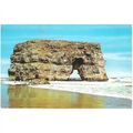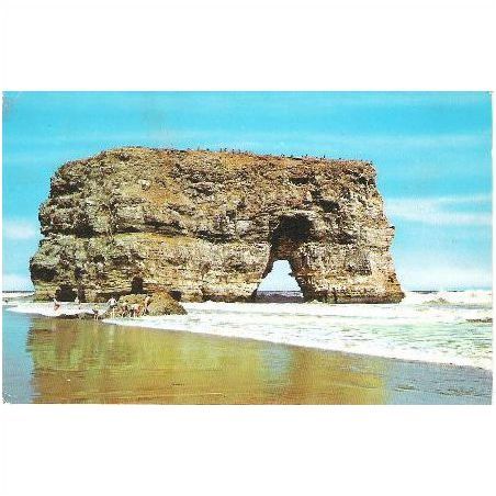

Marsden Bay, South Shields, Tyne & Wear - Rock, arch - postcard 1970s
- Condition : Used
- Dispatch : 2 Days
- Brand : None
- ID# : 102928871
- Quantity : 1 item
- Views : 1693
- Location : United Kingdom

- Seller : justthebook (+1699)
- Barcode : None
- Start : Sat 20 Apr 2013 13:32:25 (EDT)
- Close : Run Until Sold
- Remain : Run Until Sold
Checks/Cheques
 for 1 item(s) edit
Shipping Calculator
More Listings from This Seller view all


Seller's Description
- Postcard
- Picture / Image: The Rock [a natural arch], Marsden Bay, South Shields, Tyne & Wear
- Publisher: none given but probably Photo Precision (PT20685)
- Postally used: no - written and franked but not posted
- Stamp: GB Christmas Stamp 1969 4d (unfranked)
- Postmark(s): n/a
- Sent to: Station Road, Birchington, Kent
- Notes / condition:
Please ask if you need any other information and I will do the best I can to answer.
------------------------------------------------
Postage & Packing:
UK (incl. IOM, CI & BFPO): 99p
Europe: £1.60
Rest of world (inc. USA etc): £2.75
No additional charges for more than one postcard. You can buy as many postcards from me as you like and you will just pay the fee above once. (If buying postcards with other things such as books, please contact or wait for invoice before paying).
Payment Methods:
UK - PayPal, Cheque (from UK bank) or postal order
Outside UK: PayPal ONLY (unless otherwise stated) please. NO non-UK currency checks or money orders (sorry).
NOTE: All postcards are sent in brand new stiffened envelopes which I have bought for the task. These are specially made to protect postcards and you may be able to re-use them. In addition there are other costs to sending so the above charge is not just for the stamp!
I will give a full refund if you are not fully satisfied with the postcard.
----------------------------------------------
Text from the free encyclopedia WIKIPEDIA may appear below to give a little background information (internal links may not work) :
*************
Marsden is a suburb in South Shields, North East England, located on the North Sea coast.
Marsden was originally a small village, consisting of farms, a few cottages and a lighthouse at Souter Point. Local industry consisted of a small limestone quarry.[1]
The nearby Marsden Bay includes the Marsden Rock sea stack. The Leas, located to the north, is an important seabird sanctuary. This land, along with Souter Lighthouse (the first lighthouse in the world to be powered by alternating current), is now owned by the National Trust.
In the 1870s, the Whitburn Coal Company bought the five local quarries, two of which were developed as the Lighthouse (Marsden) Quarries.[2] After a failed attempt in 1874 due to water ingress to develop a shaft into the Northumberland Coalfield, in 1877 a second development using the Kind-Chaudron process, created access to the Bensham seam through two 13 feet (4.0 m) diameter shafts, with No.1 having a depth of 180 fathoms (1,100 ft; 330 m) and No.2 with a depth of 115 fathoms (690 ft; 210 m).[2]
The company built the twin-track South Shields, Marsden, and Whitburn Colliery Railway, leaving the North Eastern Railway line at Westoe Lane, South Shields and travelling to Marsden via two intermediate stations.[1] Built to serve the colliery and opened in May 1879, the line served the Lighthouse limestone quarry, a paper manufactory, and local farms. On the 19 March 1888 the line opened to the public.[1]
The industrial development of the area required additional workers. The company built a new Marsden village, located between the Lighthouse Quarries and Whitburn Colliery. Designed to house 700+ people, there were: 135 houses; 9 streets; a church and a Methodist chapel; Co-op store; Post Office; school; and a Miners Institute. Located directly on the cliff top, resulting in an exposed and often weather-beaten experience, many wives refused to move to the village, meaning that most miners lived in South Shields and commuted daily using the newly constructed railway.[1]
The village gave its name to the ""Marsden Rattler"", a passenger train which ran on the railway via the North Eastern Railway main line to South Shields.
By the time of nationalisation in 1945 into the National Coal Board, the site employed just under 1,500 miners.[2] The railway line itself became the first nationalised passenger line on 1 January 1947. Passenger service was officially withdrawn on 14 November 1953, but trains remained running until 23 November.[1]
Due to higher levels of water ingress as the mine shafts were developed under the North Sea, and resultant higher costs of operation and coal extraction, it was decided to close the mine in the mid-1960s. The final shift came up fro shaft bottom on 8 June 1968.[2] A stack was blown up as it was deemed dangerous by an arch collapsing
With the closure of the mine, it was decided to demolish the village, due to coastal erosion and the economic need to heavily invest in the village to bring it up to modern living and sanitation standards. What remains are five rows of Victorian terraced houses, the small chapel and a primary school, although this is technically now located in Whitburn.[2]
The railway line survived the colliery's closure, servicing the paper mill, but it also closed in 1993 and was lifted.[1]
type=printed postcards
theme=topographical: british
sub-theme=england
county/ country=northumberland
number of items=single
period=1945 - present
postage condition=unposted
Listing Information
| Listing Type | Gallery Listing |
| Listing ID# | 102928871 |
| Start Time | Sat 20 Apr 2013 13:32:25 (EDT) |
| Close Time | Run Until Sold |
| Starting Bid | Fixed Price (no bidding) |
| Item Condition | Used |
| Bids | 0 |
| Views | 1693 |
| Dispatch Time | 2 Days |
| Quantity | 1 |
| Location | United Kingdom |
| Auto Extend | No |