Little Chart, Kent Primrose Path 1984 postcard
- Condition : Used
- Dispatch : 2 Days
- Brand : None
- ID# : 197359696
- Quantity : 1 item
- Views : 179
- Location : United Kingdom

- Seller : justthebook (+1712)
- Barcode : None
- Start : Mon 30 Nov 2020 08:07:12 (EDT)
- Close : Run Until Sold
- Remain : Run Until Sold
Checks/Cheques
 for 1 item(s) edit
Shipping Calculator
More Listings from This Seller view all


Seller's Description
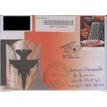
- Postcard
- Picture / Image: Primrose Path, Little Chart
- Publisher: East Kenet Federation of Women's Institutes
- Postally used: no - written but not posted
- Stamp: n/a
- Postmark(s): n/a
- Sent to: n/a
- Notes & Key words:
------------------------------------------------
Postage & Packing:
UK (incl. IOM, CI & BFPO): 99p
Europe: £1.60
Rest of world (inc. USA etc): £2.75
No additional charges for more than one postcard. You can buy as many postcards from me as you like and you will just pay the fee above once. (If buying postcards with other things such as books, please contact or wait for invoice before paying).
Payment Methods:
UK - PayPal, Cheque (from UK bank) or postal order
Outside UK: PayPal or Google Checkout ONLY please. NO non-UK currency checks or money orders (sorry).
NOTE: All postcards are sent in brand new stiffened envelopes which I have bought for the task. These are specially made to protect postcards and you may be able to re-use them. In addition there are other costs to sending so the above charge is not just for the stamp!
----------------------------------------------
Text from the free encyclopedia WIKIPEDIA may appear below to give a little background information:
*************
Little Chart is a civil parish [2] and small village to the north-east of Ashford in Kent, South East England. The parish has an area of 1,485 acres (6.01 km2), and a population of 239. Within the parish boundaries are two hamlets: Little Chart Forstal (the term forstal means the land in front of a farm and farmyard; cp Painters Forstal [3]); and Rooting Street.
The main property in the district, Surrenden Park [4], to the south of the village, was owned by the Dering family for over 400 years; the family estate covered much of this part of Kent. Part of their property was Calehill Park [5], to the north. Neither property now exists: Surrenden succumbed to fire in 1952; Calehill was demolished in 1951.
The original village church, dedicated to St Mary the Virgin and the Holy Rood, was wrecked in 1944 by a V-1 flying bomb during World War II.[6]; it stood on a site further upstream from the village, near Chart Court. The new church is now within the village [7].
The Ford Paper Mill, named after the one-time ford over the Great Stour, has a long history, and is still in operation dealing in salvaged paper. [8]
The Stour Valley Walk, which follows the Great Stour river, and the Greensand Way, from north to south, are both routed through the village. The village public house is the Swan Inn.
Listing Information
| Listing Type | Gallery Listing |
| Listing ID# | 197359696 |
| Start Time | Mon 30 Nov 2020 08:07:12 (EDT) |
| Close Time | Run Until Sold |
| Starting Bid | Fixed Price (no bidding) |
| Item Condition | Used |
| Bids | 0 |
| Views | 179 |
| Dispatch Time | 2 Days |
| Quantity | 1 |
| Location | United Kingdom |
| Auto Extend | No |