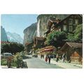
Lauterbrunnen, Bern, Switzerland - Dorfpartie, Staubbach Grosshorn posted 1964
- Condition : Used
- Dispatch : 2 Days
- Brand : None
- ID# : 119591357
- Quantity : 1 item
- Views : 514
- Location : United Kingdom

- Seller : justthebook (+1699)
- Barcode : None
- Start : Sun 29 Sep 2013 16:10:48 (EDT)
- Close : Run Until Sold
- Remain : Run Until Sold
Checks/Cheques
 for 1 item(s) edit
Shipping Calculator
More Listings from This Seller view all


Seller's Description
- Postcard
- Picture / Image: Lauterbrunnen - Dorfpartie mit Staubbach Grosshorn
- Publisher: E. Gyger
- Postally used: yes
- Stamp: Switerland 30f red Zurich defin.
- Postmark(s): Spiez 9 June 1964 cds
- Sent to: Whitley, near Warrington, Lancashire, England
- Notes / condition:
Please ask if you need any other information and I will do the best I can to answer.
Image may be low res for illustrative purposes - if you need a higher definition image then please contact me and I may be able to send one.
------------------------------------------------
Postage & Packing:
UK (incl. IOM, CI & BFPO): 99p
Europe: £1.60
Rest of world (inc. USA etc): £2.75
No additional charges for more than one postcard. You can buy as many postcards from me as you like and you will just pay the fee above once. (If buying postcards with other things such as books, please contact or wait for invoice before paying).
Payment Methods:
UK - PayPal, Cheque (from UK bank) or postal order
Outside UK: PayPal ONLY (unless otherwise stated) please. NO non-UK currency checks or money orders (sorry).
NOTE: All postcards are sent in brand new stiffened envelopes which I have bought for the task. These are specially made to protect postcards and you may be able to re-use them. In addition there are other costs to sending so the above charge is not just for the stamp!
I will give a full refund if you are not fully satisfied with the postcard.
----------------------------------------------
Text from the free encyclopedia WIKIPEDIA may appear below to give a little background information (internal links may not work) :
*************
Lauterbrunnen is a municipality in the Interlaken-Oberhasli administrative district in the canton of Bern in Switzerland.
The municipality lies in the Lauterbrunnen Valley and comprises the villages Lauterbrunnen, Wengen, Mürren, Gimmelwald, Stechelberg, and Isenfluh. The population of the Lauterbrunnen village is less than that of Wengen, but greater than that of the others.
Lauterbrunnen was first mentioned in 1240 as ""in claro fonte"", a Romance language place name meaning ""clear spring"".[citation needed] By 1253 it was known to German speakers as Liuterbrunnon which by 1268 had the alternate spelling of Luterbrunnen.[3] While the meaning of brunnen is undoubtedly spring or fountain, there is some dispute about the meaning of lauter: Some translate it as clear, clean or bright (which compares to the earlier Romance language meaning of the place mentioned above) while others translate it as ""many"" or ""louder"". A local explanation is that the name Lauterbrunnen means ""many springs"" using a modern meaning of the word lauter in German: however this could be an example of a folk etymology.
Lauterbrunnen is first mentioned in 1240 as in claro fonte. In 1304 it was mentioned as Luterbrunnen.[3]
The oldest trace of a settlement in the area is a single Roman coin which was discovered in the Blumental.
When the Lauterbrunnen valley first appears in the historic record, during the 13th century, it was owned by the Freiherr of Wädenswil. In 1240 the Freiherr of Wädenswil sold the Sefinen valley to Interlaken Abbey. Over the following century, the Abbey and other local lords began to expand their power in the Lauterbrunnen and neighboring valleys. However, around 1300, the Lord of Turn began to settle his Walser speaking people in the nearby Lötschen valley and into the highlands of the Lauterbrunnen valley. By 1346, the Walser villages of Lauterbrunnen, Gimmelwald, Mürren, Sichellauenen and Trachsellauenen all had village governments and a certain amount of independence under the Abbey. Three years later, much of the Bernese Oberland unsuccessfully rose up against Abbey. When the Abbey suppressed the rebellion, the Walser villages bore the brunt of the Abbey's wrath.[3]
By the 15th century, the villages of the valley were part of the large parish of Gsteig bei Interlaken (now part of Gsteigwiler). In 1487-88 the villagers in Lauterbrunnen built a filial church of the parish. In 1506, the parish appointed a full-time priest for Lauterbrunnen. In 1528, the city of Bern adopted the new faith of the Protestant Reformation and began imposing it on the Bernese Oberland. Lauterbrunnen joined many other villages and the Abbey in an unsuccessful rebellion against the new faith. After Bern imposed its will on the Oberland, they secularized the Abbey and annexed all the Abbey lands. Lauterbrunnen became the center of a new Reformed parish.[3]
Mines were built in the Trachsellauenen area in the upper valley beginning in the late 16th century. An iron smelter was built in Zweilütschinen (now part of Gündlischwand) in 1715 to process the iron ore from Trachsellauenen. However most of the money from the mines went to the noble landowners. The villagers remained very poor. In the 17th and 18th centuries the poverty was so widespread that many of the villagers joined mercenary regiments or emigrated. A majority of the emigrants moved to the Carolinas in the United States. Beginning in the late 18th century, foreign mountain climbers began to use Lauterbrunnen as a starting point for their expeditions into the nearby Alps. Initially the climbers stayed in the village rectory. However, as Lauterbrunnen's fame grew and with the completion of a road from Interlaken in 1834 and the 1890 Bernese Oberland Railway, more hotels were needed for tourists. As new hotels were built, other tourist infrastructure was also built in the village. They built cable cars to Mürren in 1891 and to Wengen in 1893. But the most significant piece of infrastructure was the Jungfrau railway which was built in 1912. The Jungfrau rack railway runs 9 km (5.6 mi) from Kleine Scheidegg to the highest railway station in Europe at Jungfraujoch. The railway runs almost entirely within a tunnel built into the Eiger and Mönch mountains and contains two stations in the middle of the tunnel, where passengers can disembark to observe the neighboring mountains through windows built into the mountainside. In 1909 the English brothers Walter and Arnold Lunn popularized skiing, curling and bobsledding at Lauterbrunnen. These winter sports provided a whole new group of winter tourists and converted the summer tourist industry into a year-round business. The tourist economy of Lauterbrunnen was devastated due to World War I and II and the Great Depression. However, following the end of World War II, tourism rebounded. Many new vacation homes and chalets were built along with ski lifts, chair lifts and a heliport.[3]
Lauterbrunnen has an area of 164.56 km2 (63.54 sq mi).[2] Of this area, 36.79 km2 (14.20 sq mi) or 22.4% is used for agricultural purposes, while 28.84 km2 (11.14 sq mi) or 17.5% is forested. Of the rest of the land, 2.31 km2 (0.89 sq mi) or 1.4% is settled (buildings or roads), 1.08 km2 (0.42 sq mi) or 0.7% is either rivers or lakes and 95.39 km2 (36.83 sq mi) or 58.0% is unproductive land.[4]
Of the built up area, housing and buildings made up 0.7% and transportation infrastructure made up 0.5%. Out of the forested land, 13.6% of the total land area is heavily forested and 2.0% is covered with orchards or small clusters of trees. Of the agricultural land, 3.5% is pastures and 18.9% is used for alpine pastures. All the water in the municipality is flowing water. Of the unproductive areas, 10.3% is unproductive vegetation, 31.3% is too rocky for vegetation and 16.3% of the land is covered by glaciers.[4]
On 1 January 1973 the former municipality of Isenfluh merged into the municipality of Lauterbrunnen.[5]
On 31 December 2009 Amtsbezirk Interlaken, the municipality's former district, was dissolved. On the following day, 1 January 2010, it joined the newly created Verwaltungskreis Interlaken-Oberhasli.[5]
The river Weisse Lütschine flows through Lauterbrunnen and overflows its banks about once a year. The source of the river comes from melting snow high in the mountains, thus making it a very pure and clean source of water. It is common practice in the camp sites to chill drinks in the water.
Lauterbrunnen lies at the bottom of a U-shaped valley that extends south and then south-westwards from the village to meet the 8 kilometers (5.0 mi) Lauterbrunnen Wall. The valley of Lauterbrunnen (Lauterbrunnental) is one of the deepest in the Alpine chain when compared with the height of the mountains that rise directly on either side. It is a true cleft, rarely more than one kilometre in width, between limestones precipices, sometimes quite perpendicular, everywhere of extreme steepness. It is to this form of the valley that it owes the numerous waterfalls from which it derives its name. The streams descending from the adjoining mountains, on reaching the verge of the rocky walls of the valley, form cascades so high that they are almost lost in spray before they reach the level of the valley. The most famous of these are the Staubbach Falls within less than one kilometres of the village of Lauterbrunnen. The height of the cascade is between 800 and 900 feet (240 and 270 m), one of the highest in Europe formed of a single unbroken fall.[6]
Trummelbach Falls is 3 km (1.9 mi) from Lauterbrunnen, connected by bus from the station.[7]
type=printed postcards
theme=topographical: rest of the world
sub-theme=europe
county/ country=switzerland
number of items=single
period=1945 - present
postage condition=posted
Listing Information
| Listing Type | Gallery Listing |
| Listing ID# | 119591357 |
| Start Time | Sun 29 Sep 2013 16:10:48 (EDT) |
| Close Time | Run Until Sold |
| Starting Bid | Fixed Price (no bidding) |
| Item Condition | Used |
| Bids | 0 |
| Views | 514 |
| Dispatch Time | 2 Days |
| Quantity | 1 |
| Location | United Kingdom |
| Auto Extend | No |