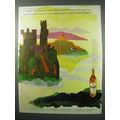
Helensburgh, Argyll & Bute - East Bay - real photo postcard, local pmk 1927
- Condition : Used
- Dispatch : 2 Days
- Brand : None
- ID# : 190892137
- Quantity : 1 item
- Views : 223
- Location : United Kingdom

- Seller : justthebook (+1704)
- Barcode : None
- Start : Fri 10 Apr 2020 04:18:02 (EDT)
- Close : Run Until Sold
- Remain : Run Until Sold
Checks/Cheques
 for 1 item(s) edit
Shipping Calculator
More Listings from This Seller view all


Seller's Description
- Postcard
- Picture / Image: East Bay, Helensburgh [Argyll & Bute] - real photo postcard
- Publisher: none stated - has number C25
- Postally used: yes
- Stamp: George V 1d red
- Postmark(s): Helensburgh 22 Aug 1927 wavy line
- Sent to: Mrs Loudon, Cartland Bridge, Lanark
- Notes / condition:
Please ask if you need any other information and I will do the best I can to answer.
Image may be low res for illustrative purposes - if you need a higher definition image then please contact me and I may be able to send one. No cards have been trimmed (unless stated).
------------------------------------------------
Postage & Packing:
Postage and packing charge should be showing for your location (contact if not sure).
No additional charges for more than one postcard. You can buy as many postcards from me as you like and you will just pay the fee above once. Please wait for combined invoice. (If buying postcards with other things such as books, please contact or wait for invoice before paying).
Payment Methods:
UK - PayPal, Cheque (from UK bank) or postal order
Outside UK: PayPal ONLY (unless otherwise stated) please. NO non-UK currency checks or money orders (sorry).
NOTE: All postcards are sent in brand new stiffened envelopes which I have bought for the task. These are specially made to protect postcards and you may be able to re-use them. In addition there are other costs to sending so the above charge is not just for the stamp!
I will give a full refund if you are not fully satisfied with the postcard.
----------------------------------------------
Text from the free encyclopedia WIKIPEDIA may appear below to give a little background information (internal links may not work) :
*************
Helensburgh (/ˈhɛlənzbərə/; Scottish Gaelic: Baile Eilidh, lit. 'town (or burgh) of Helen') is a town within the Helensburgh and Lomond Area of Argyll and Bute Council, Scotland. It also has its own Community Council. Until local government reorganisation in 1996 Helensburgh was in Dumbarton District and hence also in Strathclyde Region; prior to 1975 it was a small burgh with its own town council within Dunbartonshire. In the Middle Ages it was within the Earldom of Lennox, an area sometimes referred to as the Lennox. It lies on the north shore of the Firth of Clyde and the mouth of the Gareloch is close to the western boundary of the town.
Helensburgh is 25 miles (40 km) north-west of Glasgow. The town faces south towards Greenock across the Firth of Clyde, which is approximately 3 miles (5 km) wide at this point. Ocean-going ships can call at Greenock, but the shore at Helensburgh is very shallow, although to the west of the town the Gareloch is deep.
Helensburgh lies at the western mainland end of the Highland Boundary Fault. This means that the hills to the north of Helensburgh lie in the Highlands, whereas the land to the south of Helensburgh is in the Lowlands or Central Belt of Scotland. Consequently, there is a wide variety of landscape in the surrounding area – for example, Loch Lomond (part of Scotland's first National Park) is only 4 miles (6.4 km) over the hill to the north-east of Helensburgh. Although the Highland Boundary Fault is not geologically active, very minor earthquakes do occur occasionally in the area.
During the last Ice Age, the weight of the ice pushed the land downwards. Consequently, when the ice melted, sea levels were higher than they are now. Evidence of this can clearly be seen in Helensburgh where the first two blocks of streets nearer the sea are built on a raised beach. Behind them the land rises up quite steeply for one block and then rises more gently – and this is a former sea cliff which has been eroded. The land, now free of the weight of the ice, is slowly rising up, and the minor local earthquakes reflect this.
Further evidence of the last Ice Age can also be seen at low tide, where the beach is dotted with large boulders known as glacial erratics – these were carried from a distance inside the glaciers and dropped into their current locations when the glaciers melted.[3][4]
Listing Information
| Listing Type | Gallery Listing |
| Listing ID# | 190892137 |
| Start Time | Fri 10 Apr 2020 04:18:02 (EDT) |
| Close Time | Run Until Sold |
| Starting Bid | Fixed Price (no bidding) |
| Item Condition | Used |
| Bids | 0 |
| Views | 223 |
| Dispatch Time | 2 Days |
| Quantity | 1 |
| Location | United Kingdom |
| Auto Extend | No |