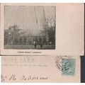
Great Yarmouth, Norfolk - Parish Church - early undivided back postcard 1904
- Condition : Used
- Dispatch : 2 Days
- Brand : None
- ID# : 209311777
- Quantity : 1 item
- Views : 71
- Location : United Kingdom

- Seller : justthebook (+1699)
- Barcode : None
- Start : Mon 04 Jul 2022 12:45:57 (EDT)
- Close : Run Until Sold
- Remain : Run Until Sold
Checks/Cheques
 for 1 item(s) edit
Shipping Calculator
More Listings from This Seller view all


Seller's Description
- Postcard
- Picture / Image: Parish Church, [Great] Yarmouth - early undivided back postcard [these were the norm before the rules changed on writing the message on the address side in 1902 - this was used a couple of years after that]
- Publisher: none given
- Postally used: yes
- Stamp: Edward VII half d. darker green [the earlier type]
- Postmark(s): Bury St. Edmunds July 27 1904 cds
- Sent to: Mr. R. A..(Atkinson?), High Street, Walsham la Willows, Bury St Edmunds
- Notes / condition:
- Postcard
Please ask if you need any other information and I will do the best I can to answer.
Image may be low res for illustrative purposes - if you need a higher definition image then please contact me and I may be able to send one. No cards have been trimmed (unless stated).
------------------------------------------------
Postage & Packing:
Postage and packing charge should be showing for your location (contact if not sure).
No additional charges for more than one postcard. You can buy as many postcards from me as you like and you will just pay the fee above once. Please wait for combined invoice. (If buying postcards with other things such as books, please contact or wait for invoice before paying).
Payment Methods:
UK - PayPal, Cheque (from UK bank) or postal order
Outside UK: PayPal ONLY (unless otherwise stated) please. NO non-UK currency checks or money orders (sorry).
NOTE: All postcards are sent in brand new stiffened envelopes which I have bought for the task. These are specially made to protect postcards and you may be able to re-use them. In addition there are other costs to sending so the above charge is not just for the stamp!
I will give a full refund if you are not fully satisfied with the postcard.
----------------------------------------------
Text from the free encyclopedia WIKIPEDIA may appear below to give a little background information (internal links may not work) :
*************
Great Yarmouth, often known to locals as Yarmouth, is a coastal town in Norfolk, England. It is located at the mouth of the River Yare, 20 miles (32 km) east of Norwich.[2]
It has been a seaside resort since 1760, and is the gateway from the Norfolk Broads to the North Sea. For hundreds of years it was a major fishing port, depending mainly on the herring fishery, but its fishing industry suffered a steep decline in the second half of the 20th century, and has now all but disappeared.[3] The discovery of oil in the North Sea in the 1960s led to a flourishing oil rig supply industry, and today it services offshore natural gas rigs. More recently, the development of renewable energy sources, especially offshore wind power, has created further opportunities for support services. A wind farm of 30 generators is within sight of the town on the Scroby Sands.
The town has a beach and two piers.
The town itself is on a thin spit sandwiched between the North Sea and River Yare. Its well known features include the historic rows (narrow streets) and the main tourist sector on the seafront. The area is linked to Gorleston, Cobholm and Southtown by Haven Bridge and to the A47, A149 and A12 by the Breydon Bridge.
The unparished urban area that makes up the town of Great Yarmouth has an area of 21.5 km2 (8.3 sq mi) and according to the Office for National Statistics in 2002 had a population of 47,288. It is the main town in the larger Borough of Great Yarmouth.[4] The ONS identify a Great Yarmouth Urban Area, which has a population of 68,317, including the sub-areas of Caister-on-Sea (8,756) and Great Yarmouth (58,032). The wider borough of Great Yarmouth has a population of around 92,500.
Great Yarmouth (Gernemwa, Yernemuth) lies near the site of the Roman fort camp of Gariannonum at the mouth of the River Yare. Its situation having attracted fishermen from the Cinque Ports, a permanent settlement was made, and the town numbered 70 burgesses before the Norman Conquest. Henry I placed it under the rule of a reeve.
In 208, King John granted a charter to Great Yarmouth. The charter gave his burgesses of Yarmouth general liberties according to the customs of Oxford, a gild merchant and weekly hustings, amplified by several later charters asserting the rights of the borough against Little Yarmouth and Gorleston. The town is bound to send to the sheriffs of Norwich every year one hundred herrings, baked in twenty four pasties, which the sheriffs are to deliver to the lord of the manor of East Carlton who is then to convey them to the King.[5]
A hospital was founded in Yarmouth in the reign of Edward I by Thomas Fastolfe. In 1551, a grammar school founded and the great hall of the old hospital was appropriated to its use. The school was closed from 1757 to 1860, was re-established by the charity trustees, and settled in new buildings in 1872.
In 1552 Edward VI granted a charter of admiralty jurisdiction, later confirmed and extended by James I. In 1668 Charles II incorporated Little Yarmouth in the borough by a charter which with one brief exception remained in force until 1703, when Queen Anne replaced the two bailiffs by a mayor. In the early 18th century Yarmouth, as a thriving herring port, was vividly and admiringly described several times in Daniel Defoe's travel journals, in part as follows:[6]
Yarmouth is an antient town, much older than Norwich; and at present, tho' not standing on so much ground, yet better built; much more compleat; for number of inhabitants, not much inferior; and for wealth, trade, and advantage of its situation, infinitely superior to Norwich.
It is plac'd on a peninsula between the River Yare and the sea; the two last lying parallel to one another, and the town in the middle: The river lies on the west-side of the town, and being grown very large and deep, by a conflux of all the rivers on this side the county, forms the haven; and the town facing to the west also, and open to the river, makes the finest key in England, if not in Europe, not inferior even to that of Marseilles itself.
The ships ride here so close, and as it were, keeping up one another, with their head-fasts on shore, that for half a mile together, they go cross the stream with their bolsprits over the land, their bowes, or heads, touching the very wharf; so that one may walk from ship to ship as on a floating bridge, all along by the shore-side: The key reaching from the drawbridge almost to the south-gate, is so spacious and wide, that in some places 'tis near one hundred yards from the houses to the wharf. In this pleasant and agreeable range of houses are some very magnificent buildings, and among the rest, the custom-house and town-hall, and some merchants houses, which look like little palaces, rather than the dwelling-houses of private men.
The greatest defect of this beautiful town, seems to be, that tho' it is very rich and encreasing in wealth and trade, and consequently in people, there is not room to enlarge the town by building; which would be certainly done much more than it is, but that the river on the land-side prescribes them, except at the north end without the gate....
From 1808 to 1814 the Admiralty in London could communicate with its ships in the port of Great Yarmouth by a shutter telegraph chain.
The town was the site of a bridge disaster and drowning tragedy on 2 May 1845 when a suspension bridge crowded with children collapsed under the weight killing 79. They had gathered to watch a clown in a barrel being pulled by geese down the river. As he passed under the bridge the weight shifted, causing the chains on the south side to snap, tipping over the bridge deck.[7]
Great Yarmouth had an electric tramway system from 1902 to 1933.
During World War I Great Yarmouth suffered the first aerial bombardment in the UK, by Zeppelin L3 on 19 January 1915. That same year on 15 August, Ernest Martin Jehan became the first and only man to sink a steel submarine with a sail rigged Q-ship, this off the coast of Great Yarmouth. It was also bombarded by the German Navy on 24 April 1916.
The town suffered Luftwaffe bombing during World War II as it was the last significant place German bombers could drop bombs before returning home, but much is left of the old town including the original 2000m protective mediaeval wall, of which two-thirds has survived. Of the 18 towers, 11 are left. On the South Quay is a 17th-century Merchant's House, as well as Tudor, Georgian and Victorian buildings. Behind South Quay is a maze of alleys and lanes known as ""The Rows"". Originally there were 145. Despite war damage, several have remained.
The northern section of the two-mile (3 km) A47 Great Yarmouth Western Bypass opened in March 1986, and the southern section in May 1985. It is now the A12.
The town was badly affected by the North Sea flood of 1953. More recent flooding has been a problem, the town flooding four times in 2006. In September 2006 the town suffered its worst flooding in years. Torrential rain caused drains to block as well as an Anglian Water pumping station to break down and this resulted in flash flooding around the town in which 90 properties were flooded up to 5 ft.[8]
On 9 November 2007 the town braced itself for more flooding as a result of a tidal surge and high tides but disaster was avoided and only a small area was under water.[9]
The Tollhouse, with dungeons, dates from the late 13th century and is said to be the oldest civic building in Britain[citation needed]. It backs on to the central library.
The market place is one of the largest in England, and has been operating since the 13th century. It is also home to the town's shopping sector and the famous Yarmouth chip stalls. The smaller area south of the market is used as a performance area for community events and for access to the town's shopping centre, Market Gates. In November 2008, a new section of Market Gates opened, including high street retailers such as Debenhams, New Look and Starbucks.
Great Yarmouth railway station, which serves the town, is the terminus of the Wherry Lines from Norwich. Before the Beeching Axe the town had a number of railway stations and a direct link to London down the east coast. The only remaining signs of these stations is the coach park where Beach Station once was and the A12 relief road which follows the route of the railway down into the embankment from Breydon Bridge.
Yarmouth has two piers, Britannia Pier (which is Grade II listed[10]) and Wellington Pier. The theatre building on the latter of the two was demolished in 2005 and reopened in 2008 as a family entertainment centre including a ten pin bowling alley with floor to ceiling windows overlooking the beach. Britannia Pier is home to the Britannia Theatre which during the summer months features well known acts including; Jim Davidson, Jethro, Basil Brush, Cannon and Ball, Chubby Brown, Chuckle Brothers and The Searchers. The theatre is one of a few end of the pier theatres left in England.
The Grade II listed Winter Gardens building sits next to the Wellington Pier. The cast iron framed glass structure was shipped by barge from Torquay in 1903. It is said this was done without the loss of a single pane of glass. Over the years, it has been used as ballroom, roller skating rink and beer garden. In the 1990s it was converted into a nightclub by comedian Jim Davidson and has since been used as a family leisure venue. It is currently closed.
Great Yarmouth's seafront, known as ""The Golden Mile"" attracts millions of visitors each year to its sandy beaches, indoor and outdoor attractions and amusement arcades. Great Yarmouth's Marine Parade has twelve Amusement Arcades located within 2 square miles (5.2 km2), including: Atlantis, The Flamingo, Circus Circus, The Golden Nugget, The Mint, Leisureland, The Majestic, The Silver Slipper, The Showboat, Magic City, Quicksilver and The Gold Rush, opened in 2007. In addition to the two piers, tourist attractions on Marine Parade include Joyland, Pirates Cove Adventure Golf, Yesterday's World, the Marina Centre, retroskate, Arnold Palmer Putting Green, the Sea Life Centre, Merrivale Model Village and the Pleasure Beach and Gardens.
The South Denes area is home to the Grade I listed Norfolk Naval Pillar, known locally as the Britannia Monument or Nelson's Monument. This tribute to Nelson was completed in 1819, 24 years before the completion of Nelson's Column in London. The monument, designed by William Wilkins, shows Britannia standing atop a globe holding an olive branch in her right hand and a trident in her left. There is a popular assumption in the town that the statue of Britannia was supposed to face out to sea but now faces inland due to a mistake during construction, although it is thought she is meant to face Nelson's birthplace at Burnham Thorpe. The monument was originally planned to mark Nelson's victory at the Battle of the Nile, but fund-raising was not completed until after his death and it was instead dedicated to England's greatest naval hero. It is currently surrounded by an industrial estate but plans are in place for the improvement of the area. The Norfolk Nelson Museum on South Quay houses the Ben Burgess collection of Nelson memorabilia and is the only dedicated Nelson museum in Britain other than that in Monmouth. Its several galleries look at Nelson's life and personality as well as what life was like for the men who sailed under him.
Charles Dickens used Yarmouth as a key location in his novel David Copperfield and described the town as ""the finest place in the universe"".[11] The author stayed at the Royal Hotel on the Marine parade while writing David Copperfield. Anna Sewell (1820–1878), famous as the author of Black Beauty, was born in a 17th-century house in Church Plain. The house is currently being used as a restaurant after being renovated in 2007.
The Time and Tide Museum on Blackfriars Road which is managed by Norfolk Museums Service was nominated in the UK Museums Awards in 2005. It was built as part of the regeneration of the south of the town in 2003. Its location in an old herring smokery harks back to the town's status as a major fishing port. Sections of the historic town wall are located opposite the museum next to the Great Yarmouth Potteries, part of which is housed in another former smoke house. The town wall is the second most complete Medieval town wall in the country, with eleven of the eighteen original turrets still standing. Other museums in the town include the National Trust's Elizabethan House and the Great Yarmouth Row Houses, managed by English Heritage.
The Maritime Heritage East partnership, based at the award winning Time and Tide Museum aims to raise the profile of maritime heritage and museum collections.
Listing Information
| Listing Type | Gallery Listing |
| Listing ID# | 209311777 |
| Start Time | Mon 04 Jul 2022 12:45:57 (EDT) |
| Close Time | Run Until Sold |
| Starting Bid | Fixed Price (no bidding) |
| Item Condition | Used |
| Bids | 0 |
| Views | 71 |
| Dispatch Time | 2 Days |
| Quantity | 1 |
| Location | United Kingdom |
| Auto Extend | No |