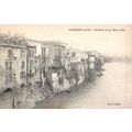
Dun Laoghaire / Kingstown, Co Dublin, Ireland - harbour - postcard 1906
- Condition : Used
- Dispatch : 2 Days
- Brand : None
- ID# : 122938953
- Quantity : 1 item
- Views : 528
- Location : United Kingdom

- Seller : justthebook (+1703)
- Barcode : None
- Start : Mon 09 Dec 2013 20:06:43 (EDT)
- Close : Run Until Sold
- Remain : Run Until Sold
Checks/Cheques
 for 1 item(s) edit
Shipping Calculator
More Listings from This Seller view all
Seller's Description
- Postcard
- Picture / Image: Kingstown [now Dun Laoghaire] in Co. Dublin, Ireland - shows harbour
- Publisher: none given
- Postally used: yes
- Stamp: Edward VII half d. lighter green
- Postmark(s): Rugeley duplex July 5 1906
- Sent to: Mr P. Bunting, Forest Road, Daneshall near Burton on Trent
- Notes / condition:
Please ask if you need any other information and I will do the best I can to answer.
Image may be low res for illustrative purposes - if you need a higher definition image then please contact me and I may be able to send one.
------------------------------------------------
Postage & Packing:
UK (incl. IOM, CI & BFPO): 99p
Europe: £1.60
Rest of world (inc. USA etc): £2.75
No additional charges for more than one postcard. You can buy as many postcards from me as you like and you will just pay the fee above once. (If buying postcards with other things such as books, please contact or wait for invoice before paying).
Payment Methods:
UK - PayPal, Cheque (from UK bank) or postal order
Outside UK: PayPal ONLY (unless otherwise stated) please. NO non-UK currency checks or money orders (sorry).
NOTE: All postcards are sent in brand new stiffened envelopes which I have bought for the task. These are specially made to protect postcards and you may be able to re-use them. In addition there are other costs to sending so the above charge is not just for the stamp!
I will give a full refund if you are not fully satisfied with the postcard.
----------------------------------------------
Text from the free encyclopedia WIKIPEDIA may appear below to give a little background information (internal links may not work) :
*************
Dún Laoghaire[6] (Irish pronunciation: [d??u?n?? '?e?r??], the older anglicisation of which, Dunleary, is also sometimes found) is a suburban seaside town in County Dublin, Ireland. It is about twelve kilometres south of Dublin city centre. Dún Laoghaire is the county town of Dún Laoghaire–Rathdown county and formerly a major port of entry from Great Britain. From 1821 to 1920 it was named Kingstown
The town's name means ""fort of Laoghaire"". This refers to Lóegaire mac Néill (modern spelling: Laoghaire Mac Néill), a 5th-century High King of Ireland, who chose the site as a sea base from which to carry out raids on Britain and Gaul. Traces of fortifications from that time have been found on the coast, and some of the stone is kept in the Maritime Museum.
The name is sometimes unofficially spelt in modern Irish orthography as Dún Laoire or Dún Laoighre.[7][8] In rare cases, the old anglicised spelling Dunleary /d?n'l??ri/ is seen.[9][7]
The present town of Dún Laoghaire dates from the 1820s. An earlier Dún Laoghaire village was located around the area where ""The Purty Kitchen"" pub is now located (sometimes mapped as ""Old Dunleary""). Dún Laoghaire had a coffee house, and a small cove, both of which are shown on a number of old maps, and it may have had a salt mine (Salthill is close by). At that time, the area on which the town is currently located was a craggy, rocky pasture area with some quarries.
Around 1800, some maps show the commencement of a small town centre along what is now Cumberland St, close to the junction with York Road. The events of the night of 18/19 November 1807 were to lead eventually to the transformation of the area. On that night, the troopships, the Prince of Wales, and the Rochdale, both of which had departed from Dublin, were driven on the rocks between Blackrock and Dún Laoghaire with the combined loss of over 400 lives. This disaster gave new impetus to an existing campaign for a new harbour to be constructed near Dublin. By 1816, the legislation was passed authorising the construction of what is now called the ""West Pier"". The lines of the current town centre including George's Street and most adjoining streets are clearly shown on maps prepared for the development of the harbour, and in particular on a John Rennie plan of 1817, when construction of that town centre had barely commenced at the western end of George's St. That street may originally have been laid out as a military road connecting the Dún Laoghaire Martello Towers—one at the ""Peoples Park"", the other near the end of the West Pier—both of which have long disappeared. Whatever its origins, the street was clearly an engineers design, being ruler-straight for all of its length (except the small western part which clearly pre-dates 1816). When King George IV came to visit the new port under construction in 1821, the name Dunleary was dropped in favour of the name ""Kingstown""; the town returned to its former name in 1920, in the lead-up to the creation of the Irish Free State. By the time the Ordnance Survey was completed around 1845, the maps show buildings on much of the street and adjacent streets.
Ireland's first railway from Dublin to Kingstown, opened for business in 1834, terminated near the West Pier. It established Kingstown as a preferred suburb of Dublin, and led to the construction of elegant residential terraces. By 1844 the ""Atmospheric Train"" (designed by Robert Mallet) connected Kingstown to Dalkey, leading to further development. The Atmospheric Train ceased in 1854, but was replaced by the extension of the railway, which was subsequently extended to the ferryport of Rosslare. The opening of the railway from Dublin saw Kingstown become a Victorian era seaside resort.
In 1890, the Kingstown Town Commissioners established the Peoples Park on the site of a depleted quarry. By 1900, the centre of the town was congested. and steps were taken to widen the street. These steps included the demolition of shop frontages on George's St from Patrick St to Mulgrave Street, and their replacement by new frontages stepped back about 5 yards (4.5m). Shops on the corner of Marine Rd and George's St were also demolished.
The main road to Dublin, through Monkstown village and Blackrock, was the sole road connection to the city of Dublin until 1932. In that year, the Eucharistic Congress, held in Dublin brought thousands of visitors to Dublin, and plans indicated that most of them would come through Dún Laoghaire. The road was considered inadequate, and a new coast road was created by connecting some short segments of road and closing some gardens. This road is now Seapoint Avenue. An agreement with the local residents to restore the area to pre-congress condition was never fulfilled.
The British 59th (2nd North Midland) Division disembarked at Kingstown in April 1916 and marched up the road to Dublin, to crush the Easter Rising. Adjacent to the Carlisle Pier and overlooked by the National Maritime Museum of Ireland, there is an anchor, recovered from the wreck of the mailboat RMS Leinster which was torpedoed over the Kish Bank in 1918, with the loss of over 500 lives.
Dún Laoghaire was hit by stray German bombs during World War II, a couple of bombs landing near the People's Park at Rosmeen Gardens. Damage from the bombs was limited to buildings.
Dún Laoghaire was once the core element of the borough of Dún Laoghaire, and until 2013 remained the only town in Ireland to have its own Vocational Education Committee. It is considered part of the Greater Dublin Area.
The area is governed locally by Dún Laoghaire-Rathdown County Council which is responsible for the provision of local services and amenities. For elections the town is part of the Dún Laoghaire local electoral area which elects six councillors. Following the 2009 local elections there are two councillors each from the Labour Party (centre left) and Fine Gael (centre right) and one each from Fianna Fáil (centrist) and PBPA (left wing).
For elections to Dáil Éireann the town is part of the Dún Laoghaire constituency which is currently represented by four TDs; two from Fine Gael and one from the Labour Party and PBPA. The most high profile TD from the constituency is current Tánaiste Eamonn Gilmore, who resides in Shankill to the south.
10] The harbour, one of the largest in the country, and base for a now limited car ferry route to Great Britain, is notable for its two granite piers. The East Pier is particularly popular with walkers, and was featured in the 1996 movie Michael Collins, where Liam Neeson (as Collins) and two of his co-stars are seen walking along a seaside promenade, which is actually the Dún Laoghaire East Pier. A band is seen playing on a bandstand in this movie scene, and this is the actual bandstand on the East Pier. The bandstand was restored to its original condition in 2010 by the Dún Laoghaire Harbour Company.
It took 42 years to construct the harbour, from 1817 to 1859. The obelisk near the old ferryport terminal at the harbour commemorates the construction of this harbour.
A lighthouse was located at the end of the East Pier, while the new headquarters of the Commissioners of Irish Lights (the General Lighthouse Authority for Ireland) is located on Harbour Road.
South of the harbour is Scotsman's Bay, where there was a Victorian seaside amusement area, with walks, shelters and baths. The walks and shelters are largely intact. The Dún Laoghaire Baths have been derelict for many years, but were repainted in bright colours in 2012.[11] Plans for restoration of this area are much debated, and some of the more ambitious ideas have been highly controversial.
A traditional Victorian-style park, the People's Park, is located at the eastern end of George's Street, and including still-functioning tea rooms.
At least one traditional ""cabman's shelter"" survives – these were small buildings built for the drivers of horse-drawn taxis.
Community facilities include the Boylan Community Centre, the Dún Laoghaire Scout Den, and a community information service in the tower building of St Michael's Church.
type=printed postcards
theme=topographical: ireland
sub-theme=ireland
county/ country=dublin
number of items=single
period=pre - 1914
postage condition=posted
Listing Information
| Listing Type | Gallery Listing |
| Listing ID# | 122938953 |
| Start Time | Mon 09 Dec 2013 20:06:43 (EDT) |
| Close Time | Run Until Sold |
| Starting Bid | Fixed Price (no bidding) |
| Item Condition | Used |
| Bids | 0 |
| Views | 528 |
| Dispatch Time | 2 Days |
| Quantity | 1 |
| Location | United Kingdom |
| Auto Extend | No |