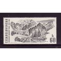
Corinth Canal, Greece - bridges - postcard c.1960s
- Condition : Used
- Dispatch : 2 Days
- Brand : None
- ID# : 179868762
- Quantity : 1 item
- Views : 212
- Location : United Kingdom

- Seller : justthebook (+1703)
- Barcode : None
- Start : Thu 18 Apr 2019 11:33:37 (EDT)
- Close : Run Until Sold
- Remain : Run Until Sold
Checks/Cheques
 for 1 item(s) edit
Shipping Calculator
More Listings from This Seller view all


Seller's Description
- Postcard
- Picture / Image: Altar frontal - St Mary Magdalene's Church, Loders, Bridport, Dorset - designed by Jane Lemon, embroidered by the Sarum Group of the Embroiders' Guild
- Publisher: probably the church / printed by Abacus - probably from a real photo
- Postally used: no
- Stamp: n/a
- Postmark(s): n/a
- Sent to: n/a
- Notes / condition:
Please ask if you need any other information and I will do the best I can to answer.
------------------------------------------------
Postage and packing charge should be showing for your location (contact if not sure).
UK - PayPal, Cheque (from UK bank) or postal order
I will give a full refund if you are not fully satisfied with the postcard.
----------------------------------------------
Loders is a village and civil parish in the English county of Dorset. It lies within the West Dorset administrative district, 2 miles (3.2 km) north-east of the town of Bridport. It is a linear village, sited in the valley of the small River Asker, between Waddon Hill and Boarsbarrow Hill. In the 2011 census the parish had a population of 518.[1]
The parish of Loders comprises three settlements. In the east is Uploders which has a public house, "The Crown", and a chapel. To the west of Uploders and separated from it by a few fields is Yondover, where the village road crosses the River Asker. The village playing field and two farms are located here. West of Yondover and separated from it by the river and the disused railway line of the Maiden Newton to Bridport branch line, is Lower Loders, generally known as just Loders. Lower Loders has a public house, "The Loders Arms", a church, a village hall, several farms, and a primary school. In his book Portrait of Dorset, Ralph Wightman gave an agricultural assessment of Loders as having "more than its share of soil variations but most of them are good soils. The result is a village of fertile fields but with an amazing difference in levels."[2]
In 1086 Loders is mentioned in the Domesday Book as Lodres.[3]
During the reign of Henry I, Baldwin de Redvers founded a seat of a Benedictine priory at Loders. The monks were reputedly the first to introduce cider-making into Dorset.[4]
A railway line used to pass through the village, although this has been in disuse for many years, since the closing of the Bridport to Maiden Newton branch line in 1975. However some features are still visible; most prominently, there are two bridges, one of which must be passed under to get from one end of the village to the other.
Loders lies within an electoral ward of the same name, which also includes the surrounding area from the edge of Bridport via Powerstock to North Poorton. The population of this ward was 1,697 at the 2011 census.[5] The ward is one of 32 that comprise the West Dorset parliamentary constituency, which is currently represented in the UK national parliament by the Conservative Oliver Letwin.
Johnny Coppin's Westcountry Christmas album includes a song called Song for Loders, which mentions many places around the area, including Eggerton, Askerswell and Muckleford, amongst others.
When frost lies thick on Egerton And every pool begins to freeze From Muckleford to Nettle Coombe And hills are hung with sparkling trees Then to Loders we must go Before the world is drowned in snow- Postcard
- Picture / Image: Corinth Canal, Greece - shows the canal with bridges
- Publisher: G. Loucatos
- Postally used: no
- Stamp: n/a
- Postmark(s): n/a
- Sent to: n/a
- Notes / condition:
Please ask if you need any other information and I will do the best I can to answer.
Image may be low res for illustrative purposes - if you need a higher definition image then please contact me and I may be able to send one. No cards have been trimmed (unless stated).
------------------------------------------------
Postage & Packing:
Postage and packing charge should be showing for your location (contact if not sure).
No additional charges for more than one postcard. You can buy as many postcards from me as you like and you will just pay the fee above once. Please wait for combined invoice. (If buying postcards with other things such as books, please contact or wait for invoice before paying).
Payment Methods:
UK - PayPal, Cheque (from UK bank) or postal order
Outside UK: PayPal ONLY (unless otherwise stated) please. NO non-UK currency checks or money orders (sorry).
NOTE: All postcards are sent in brand new stiffened envelopes which I have bought for the task. These are specially made to protect postcards and you may be able to re-use them. In addition there are other costs to sending so the above charge is not just for the stamp!
I will give a full refund if you are not fully satisfied with the postcard.
----------------------------------------------
Text from the free encyclopedia WIKIPEDIA may appear below to give a little background information (internal links may not work) :
*************
The Corinth Canal (Greek: Διώρυγα της Κορίνθου, Dhioryga tis Korinthou) is a canal that connects the Gulf of Corinth with the Saronic Gulf in the Aegean Sea. It cuts through the narrow Isthmus of Corinth and separates the Peloponnese from the Greek mainland, thus effectively making the former peninsula an island. The builders dug the canal through the Isthmus at sea level; no locks are employed. It is 6.4 kilometres (4 mi) in length and only 21.4 metres (70 ft) wide at its base, making it impassable for most modern ships. It now has little economic importance.
The canal was mooted in classical times and an abortive effort was made to build it in the 1st century AD. Construction finally got under way in 1881 but was hampered by geological and financial problems that bankrupted the original builders. It was completed in 1893 but, due to the canal's narrowness, navigational problems and periodic closures to repair landslides from its steep walls, it failed to attract the level of traffic expected by its operators. It is now used mainly for tourist traffic.
Several rulers in antiquity dreamed of digging a cutting through the Isthmus. The first to propose such an undertaking was the tyrant Periander in the 7th century BC. The project was abandoned and Periander instead constructed a simpler and less costly overland portage road, named the Diolkos or stone carriageway, along which ships could be towed from one side of the isthmus to the other.[2][3][4][5][6] Periander's change of heart is attributed variously to the great expense of the project, a lack of labour or a fear that a canal would have robbed Corinth of its dominant role as an entrepôt for goods.[7] Remnants of the Diolkos still exist next to the modern canal.[8][9][7]
The Diadoch Demetrius Poliorcetes (336–283 BC) planned to construct a canal as a means to improve his communication lines, but dropped the plan after his surveyors, miscalculating the levels of the adjacent seas, feared heavy floods.[7][10]
The philosopher Apollonius of Tyana prophesied that ill would befall anyone who proposed to dig a Corinthian canal. Three Roman rulers considered the idea but all suffered violent deaths; the historian Suetonius tells us that the Roman dictator Julius Caesar considered digging a canal through the isthmus but was assassinated before he could commence the project.[11]Caligula, his successor as the third Roman Emperor, commissioned a study in AD 40 from Egyptian experts who claimed incorrectly that the Corinthian Gulf was higher than the Saronic Gulf. As a result, they concluded, if a canal was dug the island of Aegina would be inundated. Caligula's interest in the idea got no further as he too was assassinated.[12]
The emperor Nero was the first to actually attempt to construct the canal, personally breaking the ground with a pickaxe and removing the first basket-load of soil in AD 67,[13] but the project was abandoned when he died shortly afterwards. The Roman workforce, consisting of 6,000 Jewish prisoners of war, started digging 40–50 m (130–160 ft) wide trenches from both sides, while a third group at the ridge drilled deep shafts for probing the quality of the rock (which were reused in 1881 for the same purpose).[10] According to Suetonius, the canal was dug to a distance of four stades (approximately 700 metres (2,300 ft), in other words about a tenth of the total distance across the isthmus). A memorial of the attempt in the form of a relief of Hercules was left by Nero's workers and can still be seen in the canal cutting today.[14] Other than this, as the modern canal follows the same course as Nero's, no remains have survived.[7]
The philosopher and Roman senator Herodes Atticus is also known to have considered digging a canal in the 2nd century AD, but did not manage to get a project under way.[15] The Venetians also considered it in 1687 after their conquest of the Peloponnese but likewise did not initiate a project.[16]
Listing Information
| Listing Type | Gallery Listing |
| Listing ID# | 179868762 |
| Start Time | Thu 18 Apr 2019 11:33:37 (EDT) |
| Close Time | Run Until Sold |
| Starting Bid | Fixed Price (no bidding) |
| Item Condition | Used |
| Bids | 0 |
| Views | 212 |
| Dispatch Time | 2 Days |
| Quantity | 1 |
| Location | United Kingdom |
| Auto Extend | No |