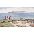
Columbia, Maryland, USA - Lake Kittamaqundi & Rouse Company HQ - postcard
- Condition : Used
- Dispatch : 2 Days
- Brand : None
- ID# : 93648052
- Quantity : 1 item
- Views : 591
- Location : United Kingdom

- Seller : justthebook (+1703)
- Barcode : None
- Start : Sat 23 Feb 2013 15:46:45 (EDT)
- Close : Run Until Sold
- Remain : Run Until Sold
Checks/Cheques
 for 1 item(s) edit
Shipping Calculator
More Listings from This Seller view all


Seller's Description
- Postcard
- Picture / Image: Columbia, Maryland - shows Lake Kittamaqundi with Rouse Company headquarters
- Publisher: D. Traub, Baltimore
- Postally used: no - written message
- Stamp: n/a
- Postmark(s): n/a
- Sent to: n/a
- Notes / condition:
Check out my !
Please ask if you need any other information and I will do the best I can to answer.
------------------------------------------------
Postage & Packing:
UK (incl. IOM, CI & BFPO): 99p
Europe: £1.60
Rest of world (inc. USA etc): £2.75
No additional charges for more than one postcard. You can buy as many postcards from me as you like and you will just pay the fee above once. (If buying postcards with other things such as books, please contact or wait for invoice before paying).
Payment Methods:
UK - PayPal, Cheque (from UK bank) or postal order
Outside UK: PayPal ONLY (unless otherwise stated) please. NO non-UK currency checks or money orders (sorry).
NOTE: All postcards are sent in brand new stiffened envelopes which I have bought for the task. These are specially made to protect postcards and you may be able to re-use them. In addition there are other costs to sending so the above charge is not just for the stamp!
I will give a full refund if you are not fully satisfied with the postcard.
----------------------------------------------
Text from the free encyclopedia WIKIPEDIA may appear below to give a little background information (internal links may not work) :
*************
Columbia is a planned community that consists of ten self-contained villages, located in Howard County, Maryland, United States. It began with the idea that a city could enhance its residents' quality of life. Creator and developer James W. Rouse saw the new community in terms of human values, rather than merely economics and engineering. Opened in 1967, Columbia was intended to not only eliminate the inconveniences of then-current subdivision design, but also eliminate racial, religious, and class segregation.
Columbia proper consists only of that territory governed by the Columbia Association, but larger areas are included under its name by the U.S. Postal Service and the census. These include several other communities which predate Columbia, including Simpsonville, Atholton, and in the case of the census, Clarksville. The census-designated place had a population of 99,615 in 2010,[2] making it the most populous community in Maryland after Baltimore.[3]
In 1962, Community Research and Development board member Melvin Berman took interest in a 1,032 acre parcel of land assembled by land developer Robert Moxley comprising four farm properties from the Carroll, Kahler, Wix, and his uncle James R. Moxley Sr's families.[4] Close to 15,000 acres were desired to create a parcel large enough for an envisioned 100,000 person development. Rouse's attorney Jack Jones set up a grid system to secretly buy land through dummy corporations to keep costs low. Moxley's firm Security Realty Company (now Security Development Group Inc),[5] negotiated most of the land deals for Jones, becoming his best client.[6][7] CRD accumulated 14,178 acres (57.38 km2), 10 percent of Howard County (located between Baltimore and Washington), from 140 separate owners. The $19,122,622 acquisition was funded by Connecticut General Life Insurance, at an average price of $1,500 per acre ($0.37/m²). In October 1963, the acquisition was revealed to the residents of Howard County, putting to rest rumors about the mysterious purchases. These had included theories that the site was to become a medical research laboratory or a giant compost heap.[8]
At this unveiling, James Rouse described Columbia as a planned new city which would avoid the leap-frog and spot development threatening the county. The new city would be complete with jobs, schools, shopping, and medical services, and a range of housing choices. Property taxes from commercial development would cover the additional services with which housing would burden the county. The urban planning process for Columbia included not only planners, but also a convened panel of nationally recognized experts in the social sciences, known as the Work Group. Meeting for two days, twice a month, for half a year, the Work Group suggested innovations for planners in education, recreation, religion, and health care, as well as ways of improving social interactions. Columbia's open classrooms, interfaith centers, and the then-novel idea of a health maintenance organization (HMO) with a group practice of medical doctors (the Columbia Medical Plan) sprung from these meetings. The community's physical plan, with neighborhood and village centers, was also decided. Columbia's ""New Town District"" zoning ordinance gave developers great flexibility about what to put where, without requiring county approval for each specific project.
Columbia was never incorporated; some governance, however, is provided by the Columbia Association, which manages common areas and functions as a homeowner association with regard to private property. The first manager of the Columbia Association was John Estabrook Slayton (d. 1967). For Slayton's contributions to the early planning of Columbia, the community center in the Wilde Lake village, Slayton House, was named for him. Wilde Lake was the first village area to be developed in Columbia; accordingly, the town's first high school was Wilde Lake High School, which opened in 1971 as a ""model school for the nation"". Constructed in the open classroom style, it was razed in 1994, but reconstructed on the same site in 1996.
Two historic buildings in Columbia, Dorsey Hall and Woodlawn, were listed on the National Register of Historic Places in 1973.[9] Both were once homes of prominent Howard County citizens.
type=printed postcards
theme=topographical: rest of the world
sub-theme=north america
county/ country=united states
number of items=single
period=1945 - present
postage condition=unposted
Listing Information
| Listing Type | Gallery Listing |
| Listing ID# | 93648052 |
| Start Time | Sat 23 Feb 2013 15:46:45 (EDT) |
| Close Time | Run Until Sold |
| Starting Bid | Fixed Price (no bidding) |
| Item Condition | Used |
| Bids | 0 |
| Views | 591 |
| Dispatch Time | 2 Days |
| Quantity | 1 |
| Location | United Kingdom |
| Auto Extend | No |