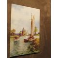
Aberfoyle, Stirling - Main Street - cars, shops Hail Caledonia postcard c.1980s
- Condition : Used
- Dispatch : 2 Days
- Brand : None
- ID# : 93648226
- Quantity : 1 item
- Views : 1658
- Location : United Kingdom

- Seller : justthebook (+1703)
- Barcode : None
- Start : Sat 23 Feb 2013 15:49:49 (EDT)
- Close : Run Until Sold
- Remain : Run Until Sold
Checks/Cheques
 for 1 item(s) edit
Shipping Calculator
More Listings from This Seller view all
Seller's Description
- Postcard
- Picture / Image: Main Street, Aberfoyle, Stirling
- Publisher: Hail Caledonia (Whiteholme)
- Postally used: no
- Stamp: n/a
- Postmark(s): n/a
- Sent to: n/a
- Notes / condition:
Please ask if you need any other information and I will do the best I can to answer.
------------------------------------------------
Postage & Packing:
UK (incl. IOM, CI & BFPO): 99p
Europe: £1.60
Rest of world (inc. USA etc): £2.75
No additional charges for more than one postcard. You can buy as many postcards from me as you like and you will just pay the fee above once. (If buying postcards with other things such as books, please contact or wait for invoice before paying).
Payment Methods:
UK - PayPal, Cheque (from UK bank) or postal order
Outside UK: PayPal ONLY (unless otherwise stated) please. NO non-UK currency checks or money orders (sorry).
NOTE: All postcards are sent in brand new stiffened envelopes which I have bought for the task. These are specially made to protect postcards and you may be able to re-use them. In addition there are other costs to sending so the above charge is not just for the stamp!
I will give a full refund if you are not fully satisfied with the postcard.
----------------------------------------------
Text from the free encyclopedia WIKIPEDIA may appear below to give a little background information (internal links may not work) :
*************
(Scottish Gaelic: Obar Phuill) is a village in the region of Stirling, Scotland, 27 miles (43 km) northwest of Glasgow.
The town is situated on the River Forth at the base of Craigmore (420 metres high). Since 1885, when the Duke of Montrose constructed a road over the eastern shoulder of Craigmore to join the older road at the entrance of the Trossachs pass, Aberfoyle has become the alternative route to the Trossachs and Loch Katrine; this road, known as the Duke's Road or Duke's Pass, was opened to the public in 1931 when the Forestry Commission acquired the land.
Loch Ard, about two miles (3 km) west of Aberfoyle, lies 40 metres above the sea. It is three miles (5 km) long (including the narrows at the east end) and one mile (1½ km) broad. Towards the west end is Eilean Gorm (the green isle), and near the north-western shore are the falls of Ledard. Two miles northwest is Loch Chon, at 90m above the sea, 1+1/4 miles (2.0 kilometres) long, and about half a mile broad. It drains by the Avon Dhu to Loch Ard, which is drained in turn by the Forth.
type=printed postcards
theme=topographical: british
sub-theme=scotland
county/ country=stirlingshire
number of items=single
period=1945 - present
postage condition=unposted
Listing Information
| Listing Type | Gallery Listing |
| Listing ID# | 93648226 |
| Start Time | Sat 23 Feb 2013 15:49:49 (EDT) |
| Close Time | Run Until Sold |
| Starting Bid | Fixed Price (no bidding) |
| Item Condition | Used |
| Bids | 0 |
| Views | 1658 |
| Dispatch Time | 2 Days |
| Quantity | 1 |
| Location | United Kingdom |
| Auto Extend | No |