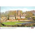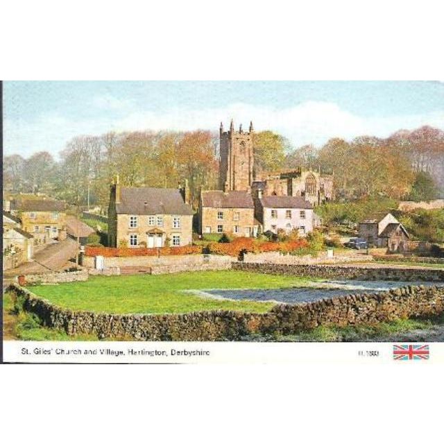

Hartington, Derbyshire - St Giles Church & Village - Dennis postcard c.1970s
- Condition : Used
- Dispatch : 2 Days
- Brand : None
- ID# : 143196697
- Quantity : 1 item
- Views : 203
- Location : United Kingdom

- Seller : justthebook (+1597)
- Barcode : None
- Start : Sat 26 Sep 2015 21:23:24 (NZST)
- Close : Run Until Sold
- Remain : Run Until Sold
Checks/Cheques
 for 1 item(s) edit
Shipping Calculator
More Listings from This Seller view all


Seller's Description
- Postcard
- Picture / Image: St. Giles' Church and Village, Hartington, Derbyshire
- Publisher: Dennis (H 1603)
- Postally used: no
- Stamp: n/a
- Postmark(s): n/a
- Sent to: n/a
- Notes / condition:
Please ask if you need any other information and I will do the best I can to answer.
Image may be low res for illustrative purposes - if you need a higher definition image then please contact me and I may be able to send one. No cards have been trimmed (unless stated).
------------------------------------------------
Postage & Packing:
Postage and packing charge should be showing for your location (contact if not sure).
No additional charges for more than one postcard. You can buy as many postcards from me as you like and you will just pay the fee above once. Please wait for combined invoice. (If buying postcards with other things such as books, please contact or wait for invoice before paying).
Payment Methods:
UK - PayPal, Cheque (from UK bank) or postal order
Outside UK: PayPal ONLY (unless otherwise stated) please. NO non-UK currency checks or money orders (sorry).
NOTE: All postcards are sent in brand new stiffened envelopes which I have bought for the task. These are specially made to protect postcards and you may be able to re-use them. In addition there are other costs to sending so the above charge is not just for the stamp!
I will give a full refund if you are not fully satisfied with the postcard.
----------------------------------------------
Text from the free encyclopedia WIKIPEDIA may appear below to give a little background information (internal links may not work) :
*************
Hartington is a village in the Derbyshire Peak District, England, lying on the River Dove close to the Staffordshire border. According to the 2001 census, the parish of Hartington Town Quarter, which also includes Pilsbury, had a population of 345. Formerly known for cheese-making and the mining of ironstone, limestone and lead, the village is now popular with tourists.
Notable buildings in the village include: the market hall (formerly the site of a market); the 13th-century parish church of Saint Giles; and 17th-century Hartington Hall. A prominent house in the centre of the village (featured in the photo 'Hartington', below right), is Bank House built by the former village mill owner and in the past used as the village bank. A half-mile (800 m) to the south of the village, on the Dove, is the fishing house of the famous angler Charles Cotton. In the north of the village is Pilsbury Castle,[1] an 11th-century motte-and-bailey castle, that survives only as an earthwork.
Near Hartington is the finest neolithic stone circle in the Peak District, Arbor Low. There are numerous ancient tumuli and cairns in the landscape around Hartington, probably dating from the Bronze Age.[citation needed]
Hartington Mill, now a private house, stands by the River Dove. This was the local water mill for grinding corn.
The village has a youth hostel at Hartington Hall, which serves two major National Cycle Network routes; the Tissington Trail and the High Peak Trail, which meet at nearby Parsley Hay. These trails pass just under one mile (1500 m) to the east of the village, and offer 30 miles (50 km) of off-road cycling and walking along old railway trackbeds through the Peak District National Park. Hartington signal box, on the site of the former Hartington railway station, and nearly two miles (3 km) distant from the village, has been renovated and converted to a Visitor Centre.
A little south of the village, overlooking the Dove, stands Wolfscote Hill (388 m at grid reference SK137583), a good viewpoint, now in the care of the National Trust.
Three miles (5 km) to the south-west lies the small settlement of Hulme End, which marks the northern starting point of the Manifold Way, an 8-mile (13 km) tarmacked walk- and cycle-route following the route of the former Leek and Manifold Valley Light Railway.
According to the English Place-Name Society the name of the village derives from the Old English for either 'Stags' hill' or 'hill connected with Heorta'.[2] Hartington was mentioned in the Domesday book as belonging to Henry de Ferrers and being worth forty shillings.[3] The parish was originally quite large, and part of the hundred of Wirksworth. Hartington had four townships, known as the Town Quarter, Nether Quarter, and Middle Quarter, and Upper Quarter, which are now all separate parishes. These became separate civil parishes in their own right in 1866.[4] They are marked on Ordnance Survey maps. Surnames that originate from this area include Heathcote.
type=printed
city/ region=hartington
period=post-war (1945 - present)
postage condition=unposted
number of items=single
size=standard (140x89mm)
Listing Information
| Listing Type | Gallery Listing |
| Listing ID# | 143196697 |
| Start Time | Sat 26 Sep 2015 21:23:24 (NZST) |
| Close Time | Run Until Sold |
| Starting Bid | Fixed Price (no bidding) |
| Item Condition | Used |
| Bids | 0 |
| Views | 203 |
| Dispatch Time | 2 Days |
| Quantity | 1 |
| Location | United Kingdom |
| Auto Extend | No |